You are here: Home > Network List > KN - Kyrgyz Seismic Telemetry Network Stations List
> Station AML KN.AML > Earthquake Result Viewer
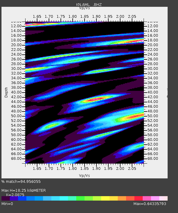
AML KN.AML - Earthquake Result Viewer
| Earthquake location: |
Solomon Islands |
| Earthquake latitude/longitude: |
-5.6/154.1 |
| Earthquake time(UTC): |
1994/04/21 (111) 02:42:15 GMT |
| Earthquake Depth: |
39 km |
| Earthquake Magnitude: |
5.4 MB, 5.6 MS |
| Earthquake Catalog/Contributor: |
WHDF/NEIC |
|
| Network: |
KN Kyrgyz Seismic Telemetry Network |
| Station: |
AML KN.AML |
| Lat/Lon: |
42.13 N/73.69 E |
| Elevation: |
3400 m |
|
| Distance: |
86.6 deg |
| Az: |
312.724 deg |
| Baz: |
100.606 deg |
| Ray Param: |
0.043858387 |
| Estimated Moho Depth: |
18.25 km |
| Estimated Crust Vp/Vs: |
2.09 |
| Assumed Crust Vp: |
6.316 km/s |
| Estimated Crust Vs: |
3.025 km/s |
| Estimated Crust Poisson's Ratio: |
0.35 |
|
| Radial Match: |
94.956055 % |
| Radial Bump: |
400 |
| Transverse Match: |
89.432655 % |
| Transverse Bump: |
400 |
| SOD ConfigId: |
4480 |
| Insert Time: |
2010-03-08 19:08:52.153 +0000 |
| GWidth: |
2.5 |
| Max Bumps: |
400 |
| Tol: |
0.001 |
|

Signal To Noise
| Channel | StoN | STA | LTA |
| KN:AML: :BHZ:19940421T02:54:23.700012Z | 2.864388 | 1.4047954E-7 | 4.904348E-8 |
| KN:AML: :BHN:19940421T02:54:23.700012Z | 1.2427948 | 3.9615433E-8 | 3.1876084E-8 |
| KN:AML: :BHE:19940421T02:54:23.700012Z | 1.0455701 | 4.3630862E-8 | 4.1729255E-8 |
| Arrivals |
| Ps | 3.2 SECOND |
| PpPs | 8.8 SECOND |
| PsPs/PpSs | 12 SECOND |


