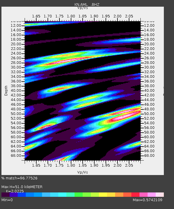
AML KN.AML - Earthquake Result Viewer

Earthquake location: Solomon Islands
Earthquake latitude/longitude: -5.7/154.1
Earthquake time(UTC): 1994/04/21 (111) 03:51:44 GMT
Earthquake Depth: 30 km
Earthquake Magnitude: 5.8 MB, 6.6 MS, 6.7 UNKNOWN, 6.6 MW
Earthquake Catalog/Contributor: WHDF/NEIC
Network: KN Kyrgyz Seismic Telemetry Network
Station: AML KN.AML
Lat/Lon: 42.13 N/73.69 E
Elevation: 3400 m
Distance: 86.7 deg
Az: 312.724 deg
Baz: 100.647 deg
Ray Param: 0.043825965
Estimated Moho Depth: 51.0 km
Estimated Crust Vp/Vs: 2.02
Assumed Crust Vp: 6.316 km/s
Estimated Crust Vs: 3.123 km/s
Estimated Crust Poisson's Ratio: 0.34
Radial Match: 96.77526 %
Radial Bump: 400
Transverse Match: 90.451454 %
Transverse Bump: 400
SOD ConfigId: 4480
Insert Time: 2010-03-08 19:08:53.654 +0000
GWidth: 2.5
Max Bumps: 400
Tol: 0.001

Signal To Noise

ChannelStoNSTALTA
KN:AML: :BHZ:19940421T04:03:54.398999Z5.18357562.5179529E-74.8575597E-8
KN:AML: :BHN:19940421T04:03:54.398999Z1.31627483.5295137E-82.6814416E-8
KN:AML: :BHE:19940421T04:03:54.398999Z2.96593838.727498E-82.9425754E-8
Arrivals
Ps8.4 SECOND
PpPs24 SECOND
PsPs/PpSs32 SECOND