You are here: Home > Network List > G - GEOSCOPE Stations List
> Station ATD Arta Cave - Arta, Republic of Djibouti > Earthquake Result Viewer
ATD Arta Cave - Arta, Republic of Djibouti - Earthquake Result Viewer
| Earthquake location: |
Mid-Indian Ridge |
| Earthquake latitude/longitude: |
-37.0/77.4 |
| Earthquake time(UTC): |
2020/04/12 (103) 06:57:47 GMT |
| Earthquake Depth: |
10 km |
| Earthquake Magnitude: |
6.1 mww |
| Earthquake Catalog/Contributor: |
NEIC PDE/us |
|
| Network: |
G GEOSCOPE |
| Station: |
ATD Arta Cave - Arta, Republic of Djibouti |
| Lat/Lon: |
11.53 N/42.85 E |
| Elevation: |
610 m |
|
| Distance: |
58.2 deg |
| Az: |
319.084 deg |
| Baz: |
147.639 deg |
| Ray Param: |
0.06301318 |
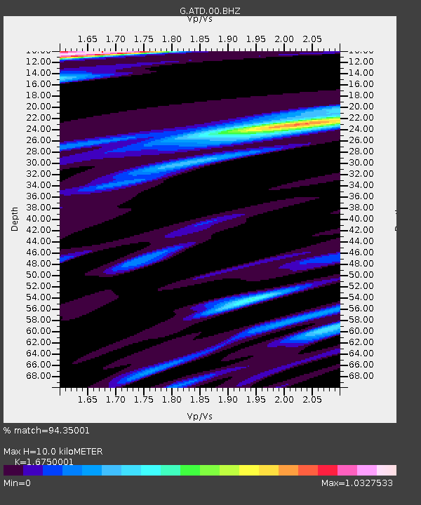
| Estimated Moho Depth: |
10.0 km |
| Estimated Crust Vp/Vs: |
1.68 |
| Assumed Crust Vp: |
6.375 km/s |
| Estimated Crust Vs: |
3.806 km/s |
| Estimated Crust Poisson's Ratio: |
0.22 |
|
| Radial Match: |
94.35001 % |
| Radial Bump: |
396 |
| Transverse Match: |
77.288666 % |
| Transverse Bump: |
400 |
| SOD ConfigId: |
21166931 |
| Insert Time: |
2020-04-26 06:59:37.351 +0000 |
| GWidth: |
2.5 |
| Max Bumps: |
400 |
| Tol: |
0.001 |
|
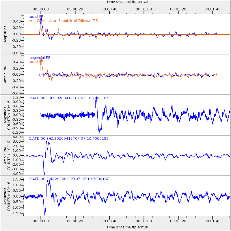
Signal To Noise
| Channel | StoN | STA | LTA |
| G:ATD:00:BHZ:20200412T07:07:10.700018Z | 27.937717 | 2.0254797E-6 | 7.249983E-8 |
| G:ATD:00:BHN:20200412T07:07:10.700018Z | 8.388715 | 8.6762117E-7 | 1.0342718E-7 |
| G:ATD:00:BHE:20200412T07:07:10.700018Z | 6.4823265 | 6.904597E-7 | 1.0651417E-7 |
| Arrivals |
| Ps | 1.1 SECOND |
| PpPs | 4.0 SECOND |
| PsPs/PpSs | 5.1 SECOND |


