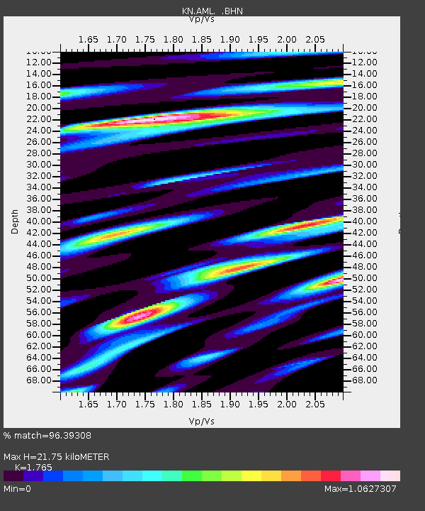
AML KN.AML - Earthquake Result Viewer

Earthquake location: Southern Sumatra, Indonesia
Earthquake latitude/longitude: -1.5/99.5
Earthquake time(UTC): 2009/08/16 (228) 07:38:21 GMT
Earthquake Depth: 20 km
Earthquake Magnitude: 6.5 MB, 6.7 MS, 6.7 MW, 6.5 MW
Earthquake Catalog/Contributor: WHDF/NEIC
Network: KN Kyrgyz Seismic Telemetry Network
Station: AML KN.AML
Lat/Lon: 42.13 N/73.69 E
Elevation: 3400 m
Distance: 49.3 deg
Az: 334.716 deg
Baz: 144.971 deg
Ray Param: 0.0687761
Estimated Moho Depth: 21.75 km
Estimated Crust Vp/Vs: 1.76
Assumed Crust Vp: 6.316 km/s
Estimated Crust Vs: 3.578 km/s
Estimated Crust Poisson's Ratio: 0.26
Radial Match: 96.39308 %
Radial Bump: 373
Transverse Match: 91.94668 %
Transverse Bump: 400
SOD ConfigId: 2622
Insert Time: 2010-03-08 19:09:22.754 +0000
GWidth: 2.5
Max Bumps: 400
Tol: 0.001

Signal To Noise

ChannelStoNSTALTA
KN:AML: :BHN:20090816T07:46:38.150012Z35.3498041.7027188E-64.8167703E-8
KN:AML: :BHE:20090816T07:46:38.150012Z19.388631.0843753E-65.592841E-8
KN:AML: :BHZ:20090816T07:46:38.150012Z17.124345.7597725E-73.3635004E-8
Arrivals
Ps2.8 SECOND
PpPs9.0 SECOND
PsPs/PpSs12 SECOND