You are here: Home > Network List > G - GEOSCOPE Stations List
> Station CLF Chambon la Foret observatory, France > Earthquake Result Viewer
CLF Chambon la Foret observatory, France - Earthquake Result Viewer
| Earthquake location: |
Turkmenistan-Iran Border Region |
| Earthquake latitude/longitude: |
37.9/57.3 |
| Earthquake time(UTC): |
2017/05/13 (133) 18:01:01 GMT |
| Earthquake Depth: |
12 km |
| Earthquake Magnitude: |
5.8 Mww |
| Earthquake Catalog/Contributor: |
NEIC PDE/us |
|
| Network: |
G GEOSCOPE |
| Station: |
CLF Chambon la Foret observatory, France |
| Lat/Lon: |
48.03 N/2.26 E |
| Elevation: |
145 m |
|
| Distance: |
40.7 deg |
| Az: |
302.585 deg |
| Baz: |
83.514 deg |
| Ray Param: |
0.074215434 |
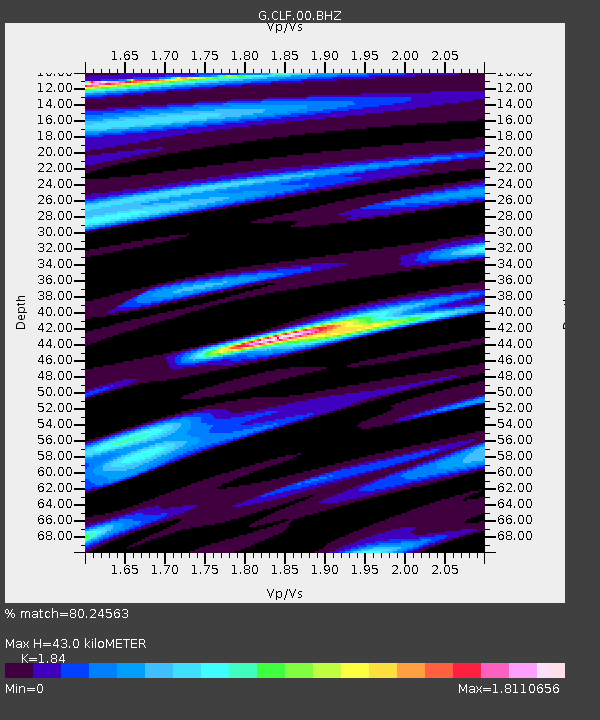
| Estimated Moho Depth: |
43.0 km |
| Estimated Crust Vp/Vs: |
1.84 |
| Assumed Crust Vp: |
6.12 km/s |
| Estimated Crust Vs: |
3.326 km/s |
| Estimated Crust Poisson's Ratio: |
0.29 |
|
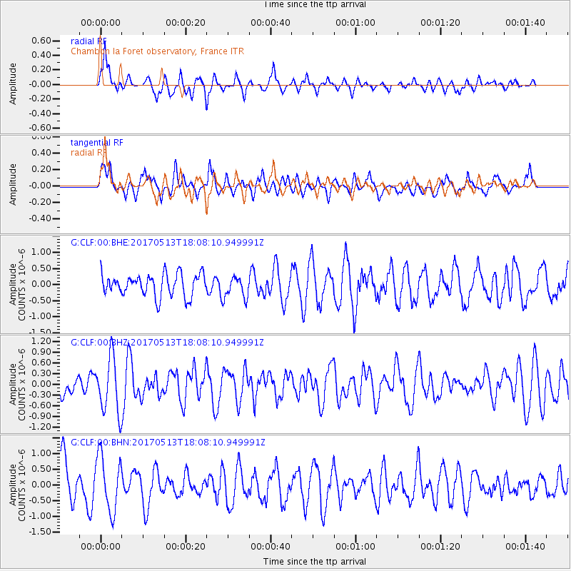
| Radial Match: |
80.24563 % |
| Radial Bump: |
400 |
| Transverse Match: |
46.37758 % |
| Transverse Bump: |
400 |
| SOD ConfigId: |
2028011 |
| Insert Time: |
2017-05-27 18:02:12.779 +0000 |
| GWidth: |
2.5 |
| Max Bumps: |
400 |
| Tol: |
0.001 |
|
Signal To Noise
| Channel | StoN | STA | LTA |
| G:CLF:00:BHZ:20170513T18:08:10.949991Z | 2.8527906 | 7.8792283E-7 | 2.761937E-7 |
| G:CLF:00:BHN:20170513T18:08:10.949991Z | 1.5733466 | 9.029584E-7 | 5.739094E-7 |
| G:CLF:00:BHE:20170513T18:08:10.949991Z | 0.9379574 | 3.2093917E-7 | 3.4216816E-7 |
| Arrivals |
| Ps | 6.3 SECOND |
| PpPs | 19 SECOND |
| PsPs/PpSs | 25 SECOND |


