You are here: Home > Network List > MM - Myanmar National Seismic Network Stations List
> Station TMU Tamu, Sagaing, Myanmar > Earthquake Result Viewer
TMU Tamu, Sagaing, Myanmar - Earthquake Result Viewer
| Earthquake location: |
Mid-Indian Ridge |
| Earthquake latitude/longitude: |
-37.0/77.4 |
| Earthquake time(UTC): |
2020/04/12 (103) 06:57:47 GMT |
| Earthquake Depth: |
10 km |
| Earthquake Magnitude: |
6.1 mww |
| Earthquake Catalog/Contributor: |
NEIC PDE/us |
|
| Network: |
MM Myanmar National Seismic Network |
| Station: |
TMU Tamu, Sagaing, Myanmar |
| Lat/Lon: |
24.23 N/94.30 E |
| Elevation: |
182 m |
|
| Distance: |
62.9 deg |
| Az: |
17.297 deg |
| Baz: |
195.121 deg |
| Ray Param: |
0.059915144 |
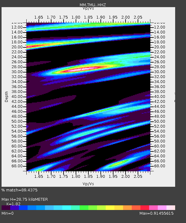
| Estimated Moho Depth: |
28.75 km |
| Estimated Crust Vp/Vs: |
1.82 |
| Assumed Crust Vp: |
6.316 km/s |
| Estimated Crust Vs: |
3.47 km/s |
| Estimated Crust Poisson's Ratio: |
0.28 |
|
| Radial Match: |
89.4375 % |
| Radial Bump: |
311 |
| Transverse Match: |
81.22643 % |
| Transverse Bump: |
400 |
| SOD ConfigId: |
21166931 |
| Insert Time: |
2020-04-26 07:02:19.487 +0000 |
| GWidth: |
2.5 |
| Max Bumps: |
400 |
| Tol: |
0.001 |
|

Signal To Noise
| Channel | StoN | STA | LTA |
| MM:TMU: :HHZ:20200412T07:07:42.867987Z | 17.524963 | 2.9962605E-6 | 1.70971E-7 |
| MM:TMU: :HHN:20200412T07:07:42.867987Z | 18.520723 | 1.6078804E-6 | 8.681521E-8 |
| MM:TMU: :HHE:20200412T07:07:42.867987Z | 2.4947069 | 2.2760263E-7 | 9.123422E-8 |
| Arrivals |
| Ps | 3.9 SECOND |
| PpPs | 12 SECOND |
| PsPs/PpSs | 16 SECOND |


