You are here: Home > Network List > TJ - Tajikistan National Seismic Network Stations List
> Station CHRDR Chorukh Dayron, Tajikistan > Earthquake Result Viewer
CHRDR Chorukh Dayron, Tajikistan - Earthquake Result Viewer
| Earthquake location: |
Mid-Indian Ridge |
| Earthquake latitude/longitude: |
-37.0/77.4 |
| Earthquake time(UTC): |
2020/04/12 (103) 06:57:47 GMT |
| Earthquake Depth: |
10 km |
| Earthquake Magnitude: |
6.1 mww |
| Earthquake Catalog/Contributor: |
NEIC PDE/us |
|
| Network: |
TJ Tajikistan National Seismic Network |
| Station: |
CHRDR Chorukh Dayron, Tajikistan |
| Lat/Lon: |
40.39 N/69.67 E |
| Elevation: |
580 m |
|
| Distance: |
77.3 deg |
| Az: |
353.92 deg |
| Baz: |
173.623 deg |
| Ray Param: |
0.05041279 |
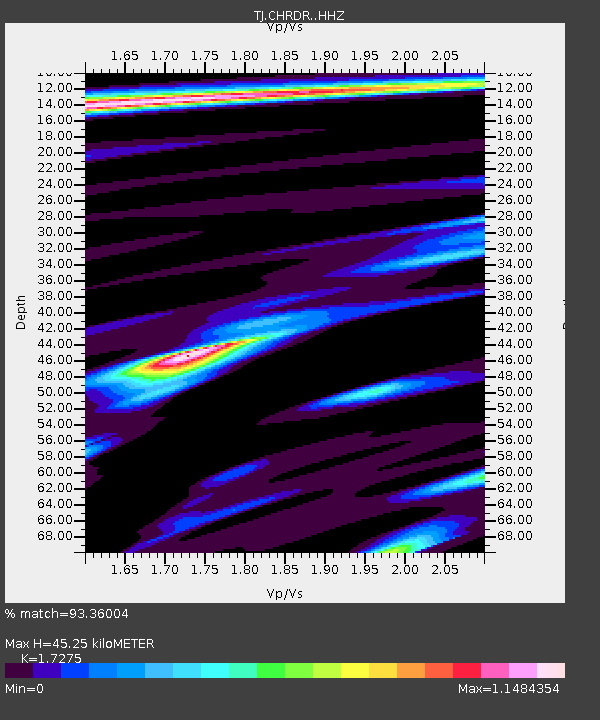
| Estimated Moho Depth: |
45.25 km |
| Estimated Crust Vp/Vs: |
1.73 |
| Assumed Crust Vp: |
6.316 km/s |
| Estimated Crust Vs: |
3.656 km/s |
| Estimated Crust Poisson's Ratio: |
0.25 |
|
| Radial Match: |
93.36004 % |
| Radial Bump: |
287 |
| Transverse Match: |
79.40928 % |
| Transverse Bump: |
400 |
| SOD ConfigId: |
21166931 |
| Insert Time: |
2020-04-26 07:03:16.925 +0000 |
| GWidth: |
2.5 |
| Max Bumps: |
400 |
| Tol: |
0.001 |
|

Signal To Noise
| Channel | StoN | STA | LTA |
| TJ:CHRDR: :HHZ:20200412T07:09:10.950018Z | 53.049454 | 5.351829E-6 | 1.0088377E-7 |
| TJ:CHRDR: :HHN:20200412T07:09:10.950018Z | 13.3270445 | 1.5559266E-6 | 1.1674957E-7 |
| TJ:CHRDR: :HHE:20200412T07:09:10.950018Z | 4.0679965 | 4.507071E-7 | 1.1079338E-7 |
| Arrivals |
| Ps | 5.4 SECOND |
| PpPs | 19 SECOND |
| PsPs/PpSs | 24 SECOND |


