You are here: Home > Network List > TS - TERRAscope (Southern California Seismic Network) Stations List
> Station SBC Santa Barbara, California, USA > Earthquake Result Viewer
SBC Santa Barbara, California, USA - Earthquake Result Viewer
| Earthquake location: |
Mexico-Guatemala Border Region |
| Earthquake latitude/longitude: |
16.0/-92.4 |
| Earthquake time(UTC): |
1994/03/14 (073) 20:51:25 GMT |
| Earthquake Depth: |
169 km |
| Earthquake Magnitude: |
5.9 MB, 6.2 MS, 6.9 UNKNOWN, 6.2 MD |
| Earthquake Catalog/Contributor: |
WHDF/NEIC |
|
| Network: |
TS TERRAscope (Southern California Seismic Network) |
| Station: |
SBC Santa Barbara, California, USA |
| Lat/Lon: |
34.44 N/119.71 W |
| Elevation: |
90 m |
|
| Distance: |
30.6 deg |
| Az: |
311.933 deg |
| Baz: |
120.026 deg |
| Ray Param: |
0.07891736 |
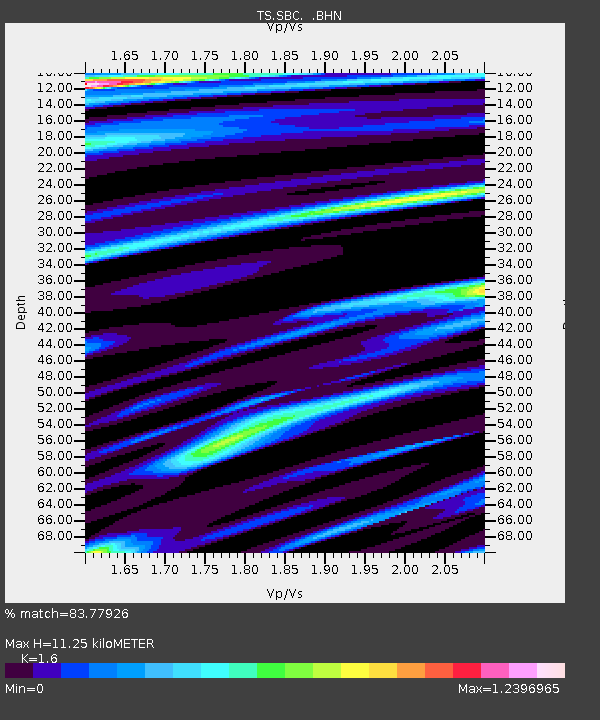
| Estimated Moho Depth: |
11.25 km |
| Estimated Crust Vp/Vs: |
1.60 |
| Assumed Crust Vp: |
6.1 km/s |
| Estimated Crust Vs: |
3.812 km/s |
| Estimated Crust Poisson's Ratio: |
0.18 |
|
| Radial Match: |
83.77926 % |
| Radial Bump: |
400 |
| Transverse Match: |
65.37606 % |
| Transverse Bump: |
400 |
| SOD ConfigId: |
16938 |
| Insert Time: |
2010-02-26 14:46:43.507 +0000 |
| GWidth: |
2.5 |
| Max Bumps: |
400 |
| Tol: |
0.001 |
|
Signal To Noise
| Channel | StoN | STA | LTA |
| TS:SBC: :BHN:19940314T20:56:53.565985Z | 1.1665226 | 9.725159E-7 | 8.33688E-7 |
| TS:SBC: :BHE:19940314T20:56:53.565985Z | 3.2791128 | 1.5302187E-6 | 4.6665627E-7 |
| TS:SBC: :BHZ:19940314T20:56:53.565985Z | 2.4761481 | 1.3047751E-6 | 5.269374E-7 |
| Arrivals |
| Ps | 1.2 SECOND |
| PpPs | 4.4 SECOND |
| PsPs/PpSs | 5.6 SECOND |


