You are here: Home > Network List > TS - TERRAscope (Southern California Seismic Network) Stations List
> Station SBC Santa Barbara, California, USA > Earthquake Result Viewer
SBC Santa Barbara, California, USA - Earthquake Result Viewer
| Earthquake location: |
Santiago Del Estero Prov., Arg. |
| Earthquake latitude/longitude: |
-28.3/-63.2 |
| Earthquake time(UTC): |
1994/04/29 (119) 07:11:30 GMT |
| Earthquake Depth: |
573 km |
| Earthquake Magnitude: |
6.4 MB, 6.0 UNKNOWN, 6.9 MW |
| Earthquake Catalog/Contributor: |
WHDF/NEIC |
|
| Network: |
TS TERRAscope (Southern California Seismic Network) |
| Station: |
SBC Santa Barbara, California, USA |
| Lat/Lon: |
34.44 N/119.71 W |
| Elevation: |
90 m |
|
| Distance: |
82.2 deg |
| Az: |
315.893 deg |
| Baz: |
132.048 deg |
| Ray Param: |
0.045367464 |
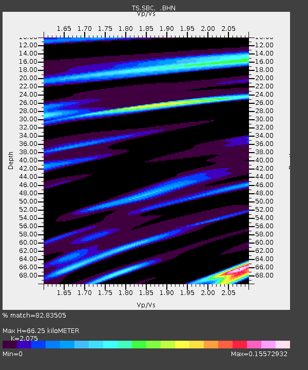
| Estimated Moho Depth: |
66.25 km |
| Estimated Crust Vp/Vs: |
2.08 |
| Assumed Crust Vp: |
6.1 km/s |
| Estimated Crust Vs: |
2.94 km/s |
| Estimated Crust Poisson's Ratio: |
0.35 |
|
| Radial Match: |
82.83505 % |
| Radial Bump: |
400 |
| Transverse Match: |
54.609283 % |
| Transverse Bump: |
400 |
| SOD ConfigId: |
16938 |
| Insert Time: |
2010-02-26 14:46:45.703 +0000 |
| GWidth: |
2.5 |
| Max Bumps: |
400 |
| Tol: |
0.001 |
|

Signal To Noise
| Channel | StoN | STA | LTA |
| TS:SBC: :BHN:19940429T07:22:20.630017Z | 0.9870726 | 1.2526082E-6 | 1.2690133E-6 |
| TS:SBC: :BHE:19940429T07:22:20.630017Z | 0.97786605 | 1.6252018E-6 | 1.661988E-6 |
| TS:SBC: :BHZ:19940429T07:22:20.630017Z | 0.89904594 | 1.5972428E-5 | 1.7765975E-5 |
| Arrivals |
| Ps | 12 SECOND |
| PpPs | 33 SECOND |
| PsPs/PpSs | 45 SECOND |


