You are here: Home > Network List > CI - Caltech Regional Seismic Network Stations List
> Station MPP McPhearson Peak > Earthquake Result Viewer
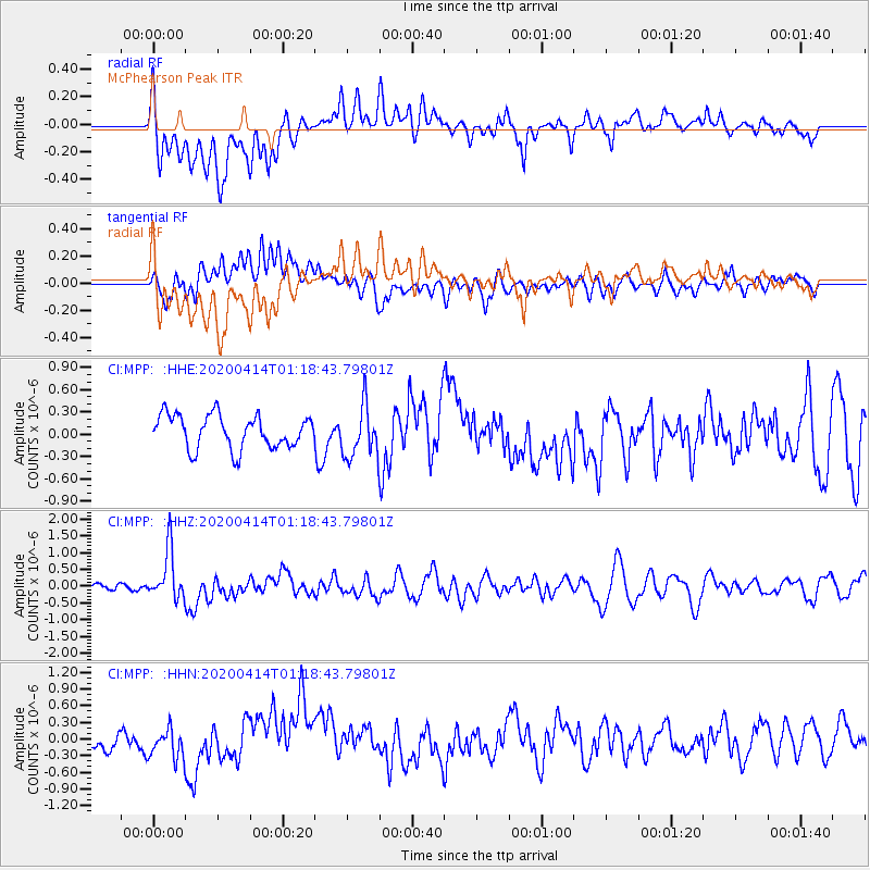
MPP McPhearson Peak - Earthquake Result Viewer
*The percent match for this event was below the threshold and hence no stack was calculated.
| Earthquake location: |
Kermadec Islands Region |
| Earthquake latitude/longitude: |
-30.4/-176.3 |
| Earthquake time(UTC): |
2020/04/14 (105) 01:06:47 GMT |
| Earthquake Depth: |
31 km |
| Earthquake Magnitude: |
6.0 Mww |
| Earthquake Catalog/Contributor: |
NEIC PDE/us |
|
| Network: |
CI Caltech Regional Seismic Network |
| Station: |
MPP McPhearson Peak |
| Lat/Lon: |
34.89 N/119.81 W |
| Elevation: |
1739 m |
|
| Distance: |
84.0 deg |
| Az: |
43.598 deg |
| Baz: |
226.456 deg |
| Ray Param: |
$rayparam |
*The percent match for this event was below the threshold and hence was not used in the summary stack. |
|
| Radial Match: |
66.41597 % |
| Radial Bump: |
400 |
| Transverse Match: |
46.67143 % |
| Transverse Bump: |
400 |
| SOD ConfigId: |
21166931 |
| Insert Time: |
2020-04-28 01:14:20.838 +0000 |
| GWidth: |
2.5 |
| Max Bumps: |
400 |
| Tol: |
0.001 |
|
Signal To Noise
| Channel | StoN | STA | LTA |
| CI:MPP: :HHZ:20200414T01:18:43.79801Z | 3.4321594 | 7.4836083E-7 | 2.1804374E-7 |
| CI:MPP: :HHN:20200414T01:18:43.79801Z | 1.5131269 | 2.4960644E-7 | 1.649607E-7 |
| CI:MPP: :HHE:20200414T01:18:43.79801Z | 1.5726407 | 3.5117614E-7 | 2.2330349E-7 |
| Arrivals |
| Ps | |
| PpPs | |
| PsPs/PpSs | |


