You are here: Home > Network List > IU - Global Seismograph Network (GSN - IRIS/USGS) Stations List
> Station PMG Port Moresby, New Guinea > Earthquake Result Viewer
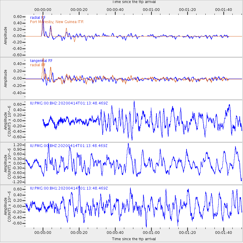
PMG Port Moresby, New Guinea - Earthquake Result Viewer
*The percent match for this event was below the threshold and hence no stack was calculated.
| Earthquake location: |
Kermadec Islands Region |
| Earthquake latitude/longitude: |
-30.4/-176.3 |
| Earthquake time(UTC): |
2020/04/14 (105) 01:06:47 GMT |
| Earthquake Depth: |
31 km |
| Earthquake Magnitude: |
6.0 Mww |
| Earthquake Catalog/Contributor: |
NEIC PDE/us |
|
| Network: |
IU Global Seismograph Network (GSN - IRIS/USGS) |
| Station: |
PMG Port Moresby, New Guinea |
| Lat/Lon: |
9.40 S/147.16 E |
| Elevation: |
90 m |
|
| Distance: |
39.9 deg |
| Az: |
293.815 deg |
| Baz: |
126.761 deg |
| Ray Param: |
$rayparam |
*The percent match for this event was below the threshold and hence was not used in the summary stack. |
|
| Radial Match: |
71.67646 % |
| Radial Bump: |
400 |
| Transverse Match: |
64.61372 % |
| Transverse Bump: |
400 |
| SOD ConfigId: |
21166931 |
| Insert Time: |
2020-04-28 01:17:28.753 +0000 |
| GWidth: |
2.5 |
| Max Bumps: |
400 |
| Tol: |
0.001 |
|
Signal To Noise
| Channel | StoN | STA | LTA |
| IU:PMG:00:BHZ:20200414T01:13:48.469Z | 4.341641 | 5.236726E-7 | 1.2061628E-7 |
| IU:PMG:00:BH1:20200414T01:13:48.469Z | 0.78454393 | 9.230322E-8 | 1.1765207E-7 |
| IU:PMG:00:BH2:20200414T01:13:48.469Z | 2.0997553 | 1.9857666E-7 | 9.4571334E-8 |
| Arrivals |
| Ps | |
| PpPs | |
| PsPs/PpSs | |


