You are here: Home > Network List > TA - USArray Transportable Network (new EarthScope stations) Stations List
> Station O17K Koliganek, Bristol Bay, AK, USA > Earthquake Result Viewer
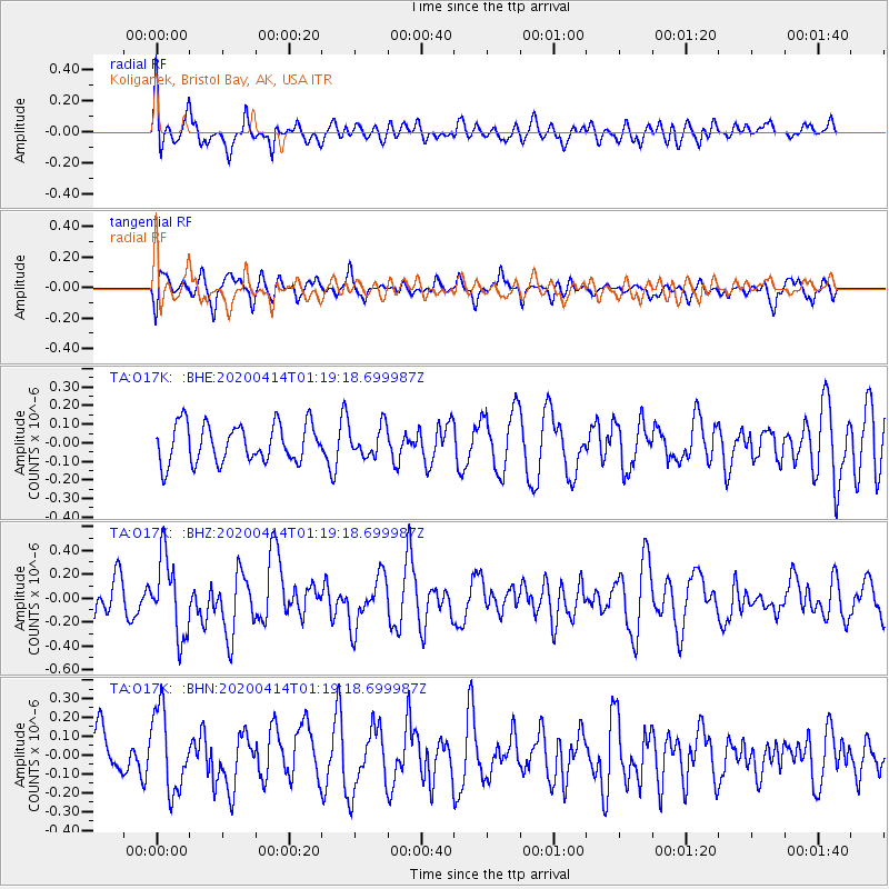
O17K Koliganek, Bristol Bay, AK, USA - Earthquake Result Viewer
*The percent match for this event was below the threshold and hence no stack was calculated.
| Earthquake location: |
Kermadec Islands Region |
| Earthquake latitude/longitude: |
-30.4/-176.3 |
| Earthquake time(UTC): |
2020/04/14 (105) 01:06:47 GMT |
| Earthquake Depth: |
31 km |
| Earthquake Magnitude: |
6.0 Mww |
| Earthquake Catalog/Contributor: |
NEIC PDE/us |
|
| Network: |
TA USArray Transportable Network (new EarthScope stations) |
| Station: |
O17K Koliganek, Bristol Bay, AK, USA |
| Lat/Lon: |
59.77 N/157.09 W |
| Elevation: |
156 m |
|
| Distance: |
91.2 deg |
| Az: |
9.606 deg |
| Baz: |
196.558 deg |
| Ray Param: |
$rayparam |
*The percent match for this event was below the threshold and hence was not used in the summary stack. |
|
| Radial Match: |
63.733624 % |
| Radial Bump: |
400 |
| Transverse Match: |
50.25091 % |
| Transverse Bump: |
400 |
| SOD ConfigId: |
21166931 |
| Insert Time: |
2020-04-28 01:21:21.764 +0000 |
| GWidth: |
2.5 |
| Max Bumps: |
400 |
| Tol: |
0.001 |
|
Signal To Noise
| Channel | StoN | STA | LTA |
| TA:O17K: :BHZ:20200414T01:19:18.699987Z | 2.8593671 | 3.2359995E-7 | 1.13171886E-7 |
| TA:O17K: :BHN:20200414T01:19:18.699987Z | 1.506892 | 2.14032E-7 | 1.4203539E-7 |
| TA:O17K: :BHE:20200414T01:19:18.699987Z | 0.7789905 | 8.00052E-8 | 1.02703694E-7 |
| Arrivals |
| Ps | |
| PpPs | |
| PsPs/PpSs | |


