You are here: Home > Network List > US - United States National Seismic Network Stations List
> Station MNTX Cornudas Mountains, Texas, USA > Earthquake Result Viewer
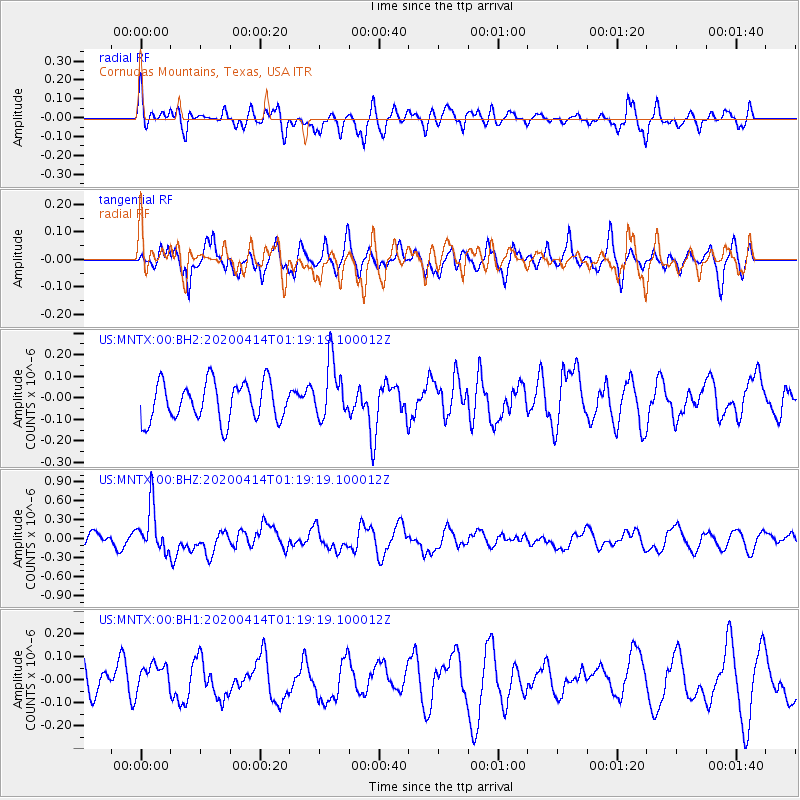
MNTX Cornudas Mountains, Texas, USA - Earthquake Result Viewer
*The percent match for this event was below the threshold and hence no stack was calculated.
| Earthquake location: |
Kermadec Islands Region |
| Earthquake latitude/longitude: |
-30.4/-176.3 |
| Earthquake time(UTC): |
2020/04/14 (105) 01:06:47 GMT |
| Earthquake Depth: |
31 km |
| Earthquake Magnitude: |
6.0 Mww |
| Earthquake Catalog/Contributor: |
NEIC PDE/us |
|
| Network: |
US United States National Seismic Network |
| Station: |
MNTX Cornudas Mountains, Texas, USA |
| Lat/Lon: |
31.70 N/105.38 W |
| Elevation: |
404 m |
|
| Distance: |
91.3 deg |
| Az: |
53.707 deg |
| Baz: |
234.791 deg |
| Ray Param: |
$rayparam |
*The percent match for this event was below the threshold and hence was not used in the summary stack. |
|
| Radial Match: |
50.63747 % |
| Radial Bump: |
400 |
| Transverse Match: |
46.13317 % |
| Transverse Bump: |
400 |
| SOD ConfigId: |
21166931 |
| Insert Time: |
2020-04-28 01:23:35.699 +0000 |
| GWidth: |
2.5 |
| Max Bumps: |
400 |
| Tol: |
0.001 |
|
Signal To Noise
| Channel | StoN | STA | LTA |
| US:MNTX:00:BHZ:20200414T01:19:19.100012Z | 3.1538124 | 3.6082028E-7 | 1.14407655E-7 |
| US:MNTX:00:BH1:20200414T01:19:19.100012Z | 0.78537744 | 6.567218E-8 | 8.361862E-8 |
| US:MNTX:00:BH2:20200414T01:19:19.100012Z | 1.4981861 | 1.332432E-7 | 8.893635E-8 |
| Arrivals |
| Ps | |
| PpPs | |
| PsPs/PpSs | |


