You are here: Home > Network List > US - United States National Seismic Network Stations List
> Station ERPA Erie, Pennsylvania, USA > Earthquake Result Viewer
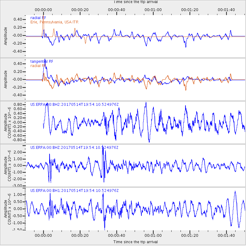
ERPA Erie, Pennsylvania, USA - Earthquake Result Viewer
*The percent match for this event was below the threshold and hence no stack was calculated.
| Earthquake location: |
Chile-Bolivia Border Region |
| Earthquake latitude/longitude: |
-20.9/-68.7 |
| Earthquake time(UTC): |
2017/05/14 (134) 19:44:23 GMT |
| Earthquake Depth: |
124 km |
| Earthquake Magnitude: |
5.6 Mww |
| Earthquake Catalog/Contributor: |
NEIC PDE/us |
|
| Network: |
US United States National Seismic Network |
| Station: |
ERPA Erie, Pennsylvania, USA |
| Lat/Lon: |
42.12 N/79.99 W |
| Elevation: |
306 m |
|
| Distance: |
63.6 deg |
| Az: |
350.669 deg |
| Baz: |
168.246 deg |
| Ray Param: |
$rayparam |
*The percent match for this event was below the threshold and hence was not used in the summary stack. |
|
| Radial Match: |
66.196884 % |
| Radial Bump: |
400 |
| Transverse Match: |
78.37215 % |
| Transverse Bump: |
400 |
| SOD ConfigId: |
2028011 |
| Insert Time: |
2017-05-28 19:59:50.814 +0000 |
| GWidth: |
2.5 |
| Max Bumps: |
400 |
| Tol: |
0.001 |
|
Signal To Noise
| Channel | StoN | STA | LTA |
| US:ERPA:00:BHZ:20170514T19:54:10.524976Z | 1.8852565 | 8.307017E-7 | 4.4063057E-7 |
| US:ERPA:00:BH1:20170514T19:54:10.524976Z | 0.95228434 | 3.7456383E-7 | 3.933319E-7 |
| US:ERPA:00:BH2:20170514T19:54:10.524976Z | 0.7279631 | 2.2850506E-7 | 3.138965E-7 |
| Arrivals |
| Ps | |
| PpPs | |
| PsPs/PpSs | |


