You are here: Home > Network List > CI - Caltech Regional Seismic Network Stations List
> Station SWS Sam W. Stewart, Westmorland, CA, USA > Earthquake Result Viewer
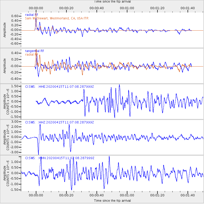
SWS Sam W. Stewart, Westmorland, CA, USA - Earthquake Result Viewer
*The percent match for this event was below the threshold and hence no stack was calculated.
| Earthquake location: |
Northern Colombia |
| Earthquake latitude/longitude: |
9.0/-74.4 |
| Earthquake time(UTC): |
2020/04/15 (106) 10:59:29 GMT |
| Earthquake Depth: |
53 km |
| Earthquake Magnitude: |
5.7 Mww |
| Earthquake Catalog/Contributor: |
NEIC PDE/us |
|
| Network: |
CI Caltech Regional Seismic Network |
| Station: |
SWS Sam W. Stewart, Westmorland, CA, USA |
| Lat/Lon: |
32.94 N/115.80 W |
| Elevation: |
140 m |
|
| Distance: |
44.9 deg |
| Az: |
308.114 deg |
| Baz: |
112.458 deg |
| Ray Param: |
$rayparam |
*The percent match for this event was below the threshold and hence was not used in the summary stack. |
|
| Radial Match: |
79.842415 % |
| Radial Bump: |
399 |
| Transverse Match: |
82.38451 % |
| Transverse Bump: |
400 |
| SOD ConfigId: |
21166931 |
| Insert Time: |
2020-04-29 11:08:55.967 +0000 |
| GWidth: |
2.5 |
| Max Bumps: |
400 |
| Tol: |
0.001 |
|
Signal To Noise
| Channel | StoN | STA | LTA |
| CI:SWS: :HHZ:20200415T11:07:08.287999Z | 8.637061 | 1.2878523E-6 | 1.491077E-7 |
| CI:SWS: :HHN:20200415T11:07:08.287999Z | 3.1305676 | 6.0391E-7 | 1.929075E-7 |
| CI:SWS: :HHE:20200415T11:07:08.287999Z | 4.0444584 | 5.380809E-7 | 1.3304152E-7 |
| Arrivals |
| Ps | |
| PpPs | |
| PsPs/PpSs | |


