You are here: Home > Network List > WI - West Indies IPGP Network Stations List
> Station BIM Morne Bigot, Anses d'Arlets, Martinique > Earthquake Result Viewer
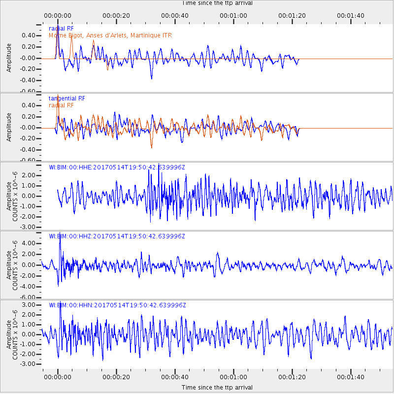
BIM Morne Bigot, Anses d'Arlets, Martinique - Earthquake Result Viewer
*The percent match for this event was below the threshold and hence no stack was calculated.
| Earthquake location: |
Chile-Bolivia Border Region |
| Earthquake latitude/longitude: |
-20.9/-68.7 |
| Earthquake time(UTC): |
2017/05/14 (134) 19:44:23 GMT |
| Earthquake Depth: |
124 km |
| Earthquake Magnitude: |
5.6 Mww |
| Earthquake Catalog/Contributor: |
NEIC PDE/us |
|
| Network: |
WI West Indies IPGP Network |
| Station: |
BIM Morne Bigot, Anses d'Arlets, Martinique |
| Lat/Lon: |
14.52 N/61.07 W |
| Elevation: |
391 m |
|
| Distance: |
36.0 deg |
| Az: |
12.695 deg |
| Baz: |
192.247 deg |
| Ray Param: |
$rayparam |
*The percent match for this event was below the threshold and hence was not used in the summary stack. |
|
| Radial Match: |
62.79463 % |
| Radial Bump: |
400 |
| Transverse Match: |
54.118103 % |
| Transverse Bump: |
400 |
| SOD ConfigId: |
2028011 |
| Insert Time: |
2017-05-28 20:01:46.844 +0000 |
| GWidth: |
2.5 |
| Max Bumps: |
400 |
| Tol: |
0.001 |
|
Signal To Noise
| Channel | StoN | STA | LTA |
| WI:BIM:00:HHZ:20170514T19:50:42.639996Z | 5.2023797 | 1.8784709E-6 | 3.6107917E-7 |
| WI:BIM:00:HHN:20170514T19:50:42.639996Z | 2.1453705 | 1.2351243E-6 | 5.7571606E-7 |
| WI:BIM:00:HHE:20170514T19:50:42.639996Z | 1.8401219 | 1.162404E-6 | 6.316995E-7 |
| Arrivals |
| Ps | |
| PpPs | |
| PsPs/PpSs | |


