You are here: Home > Network List > TA - USArray Transportable Network (new EarthScope stations) Stations List
> Station G21K Allakaket, AK, USA > Earthquake Result Viewer
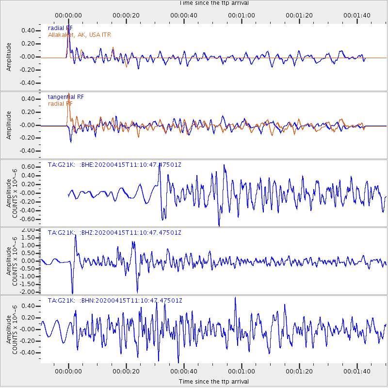
G21K Allakaket, AK, USA - Earthquake Result Viewer
*The percent match for this event was below the threshold and hence no stack was calculated.
| Earthquake location: |
Northern Colombia |
| Earthquake latitude/longitude: |
9.0/-74.4 |
| Earthquake time(UTC): |
2020/04/15 (106) 10:59:29 GMT |
| Earthquake Depth: |
53 km |
| Earthquake Magnitude: |
5.7 Mww |
| Earthquake Catalog/Contributor: |
NEIC PDE/us |
|
| Network: |
TA USArray Transportable Network (new EarthScope stations) |
| Station: |
G21K Allakaket, AK, USA |
| Lat/Lon: |
66.52 N/153.51 W |
| Elevation: |
446 m |
|
| Distance: |
77.4 deg |
| Az: |
336.221 deg |
| Baz: |
96.408 deg |
| Ray Param: |
$rayparam |
*The percent match for this event was below the threshold and hence was not used in the summary stack. |
|
| Radial Match: |
79.54553 % |
| Radial Bump: |
400 |
| Transverse Match: |
71.85424 % |
| Transverse Bump: |
400 |
| SOD ConfigId: |
21166931 |
| Insert Time: |
2020-04-29 11:23:05.517 +0000 |
| GWidth: |
2.5 |
| Max Bumps: |
400 |
| Tol: |
0.001 |
|
Signal To Noise
| Channel | StoN | STA | LTA |
| TA:G21K: :BHZ:20200415T11:10:47.47501Z | 7.8637786 | 7.837465E-7 | 9.9665385E-8 |
| TA:G21K: :BHN:20200415T11:10:47.47501Z | 1.8527021 | 1.593312E-7 | 8.599936E-8 |
| TA:G21K: :BHE:20200415T11:10:47.47501Z | 5.0548935 | 3.703964E-7 | 7.327482E-8 |
| Arrivals |
| Ps | |
| PpPs | |
| PsPs/PpSs | |


