You are here: Home > Network List > WY - Yellowstone Wyoming Seismic Network Stations List
> Station YHH Holmes Hill, YNP, WY, USA > Earthquake Result Viewer
YHH Holmes Hill, YNP, WY, USA - Earthquake Result Viewer
*The percent match for this event was below the threshold and hence no stack was calculated.
| Earthquake location: |
Northern Colombia |
| Earthquake latitude/longitude: |
9.0/-74.4 |
| Earthquake time(UTC): |
2020/04/15 (106) 10:59:29 GMT |
| Earthquake Depth: |
53 km |
| Earthquake Magnitude: |
5.7 Mww |
| Earthquake Catalog/Contributor: |
NEIC PDE/us |
|
| Network: |
WY Yellowstone Wyoming Seismic Network |
| Station: |
YHH Holmes Hill, YNP, WY, USA |
| Lat/Lon: |
44.79 N/110.85 W |
| Elevation: |
2717 m |
|
| Distance: |
47.5 deg |
| Az: |
325.009 deg |
| Baz: |
127.305 deg |
| Ray Param: |
$rayparam |
*The percent match for this event was below the threshold and hence was not used in the summary stack. |
|
| Radial Match: |
69.29181 % |
| Radial Bump: |
400 |
| Transverse Match: |
59.852978 % |
| Transverse Bump: |
400 |
| SOD ConfigId: |
21166931 |
| Insert Time: |
2020-04-29 11:29:36.762 +0000 |
| GWidth: |
2.5 |
| Max Bumps: |
400 |
| Tol: |
0.001 |
|
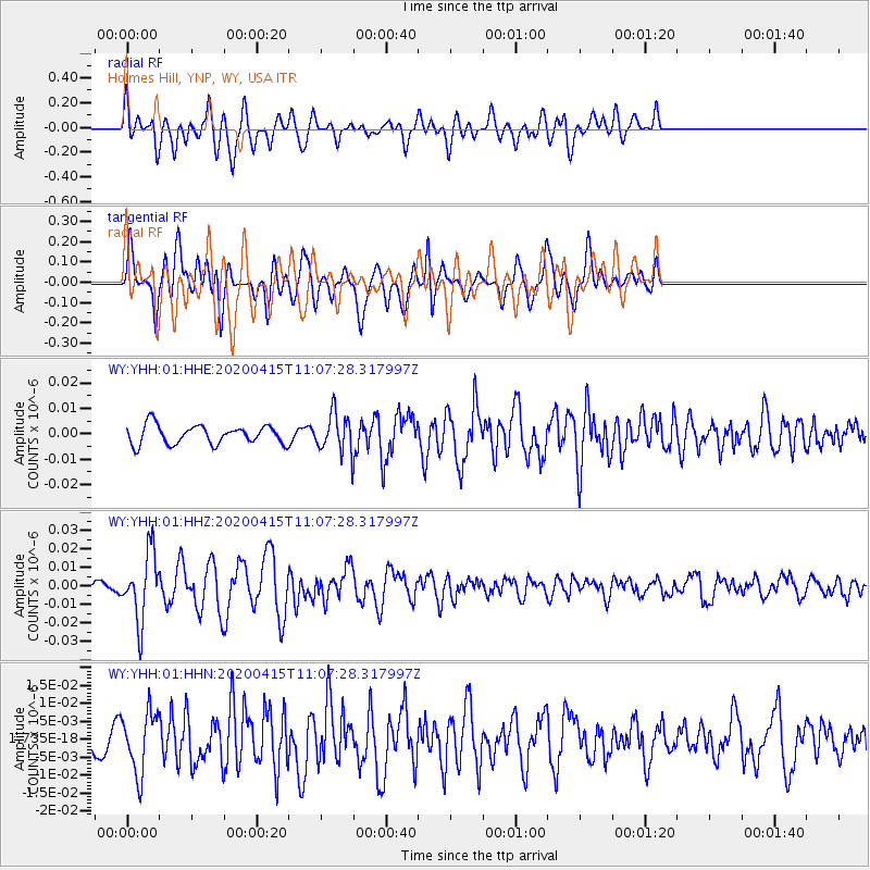
Signal To Noise
| Channel | StoN | STA | LTA |
| WY:YHH:01:HHZ:20200415T11:07:28.317997Z | 6.265711 | 1.8064576E-8 | 2.8830849E-9 |
| WY:YHH:01:HHN:20200415T11:07:28.317997Z | 2.9370232 | 8.43293E-9 | 2.8712508E-9 |
| WY:YHH:01:HHE:20200415T11:07:28.317997Z | 1.9916062 | 7.318795E-9 | 3.6748204E-9 |
| Arrivals |
| Ps | |
| PpPs | |
| PsPs/PpSs | |


