You are here: Home > Network List > TS - TERRAscope (Southern California Seismic Network) Stations List
> Station SBC Santa Barbara, California, USA > Earthquake Result Viewer
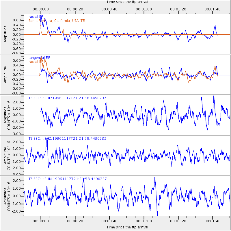
SBC Santa Barbara, California, USA - Earthquake Result Viewer
*The percent match for this event was below the threshold and hence no stack was calculated.
| Earthquake location: |
South Of Fiji Islands |
| Earthquake latitude/longitude: |
-22.2/-179.7 |
| Earthquake time(UTC): |
1996/11/17 (322) 21:11:20 GMT |
| Earthquake Depth: |
592 km |
| Earthquake Magnitude: |
5.5 MB, 6.1 UNKNOWN, 6.0 MW |
| Earthquake Catalog/Contributor: |
WHDF/NEIC |
|
| Network: |
TS TERRAscope (Southern California Seismic Network) |
| Station: |
SBC Santa Barbara, California, USA |
| Lat/Lon: |
34.44 N/119.71 W |
| Elevation: |
90 m |
|
| Distance: |
80.1 deg |
| Az: |
46.59 deg |
| Baz: |
234.55 deg |
| Ray Param: |
$rayparam |
*The percent match for this event was below the threshold and hence was not used in the summary stack. |
|
| Radial Match: |
49.910267 % |
| Radial Bump: |
400 |
| Transverse Match: |
60.35515 % |
| Transverse Bump: |
400 |
| SOD ConfigId: |
4480 |
| Insert Time: |
2010-02-26 14:47:09.304 +0000 |
| GWidth: |
2.5 |
| Max Bumps: |
400 |
| Tol: |
0.001 |
|
Signal To Noise
| Channel | StoN | STA | LTA |
| TS:SBC: :BHZ:19961117T21:21:58.449023Z | 2.2683544 | 1.1075302E-6 | 4.8825274E-7 |
| TS:SBC: :BHN:19961117T21:21:58.449023Z | 0.7568927 | 5.548971E-7 | 7.3312515E-7 |
| TS:SBC: :BHE:19961117T21:21:58.449023Z | 1.1035925 | 8.238379E-7 | 7.465056E-7 |
| Arrivals |
| Ps | |
| PpPs | |
| PsPs/PpSs | |


