You are here: Home > Network List > AK - Alaska Regional Network Stations List
> Station A21K Barrow, AK, USA > Earthquake Result Viewer
A21K Barrow, AK, USA - Earthquake Result Viewer
| Earthquake location: |
North Of Honduras |
| Earthquake latitude/longitude: |
16.9/-85.7 |
| Earthquake time(UTC): |
2020/04/16 (107) 08:04:37 GMT |
| Earthquake Depth: |
10 km |
| Earthquake Magnitude: |
6.0 mww |
| Earthquake Catalog/Contributor: |
NEIC PDE/us |
|
| Network: |
AK Alaska Regional Network |
| Station: |
A21K Barrow, AK, USA |
| Lat/Lon: |
71.32 N/156.62 W |
| Elevation: |
5.0 m |
|
| Distance: |
68.0 deg |
| Az: |
340.827 deg |
| Baz: |
102.657 deg |
| Ray Param: |
0.056606725 |
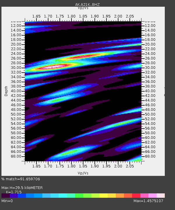
| Estimated Moho Depth: |
29.5 km |
| Estimated Crust Vp/Vs: |
1.72 |
| Assumed Crust Vp: |
6.048 km/s |
| Estimated Crust Vs: |
3.526 km/s |
| Estimated Crust Poisson's Ratio: |
0.24 |
|
| Radial Match: |
91.659706 % |
| Radial Bump: |
400 |
| Transverse Match: |
86.71351 % |
| Transverse Bump: |
400 |
| SOD ConfigId: |
21166931 |
| Insert Time: |
2020-04-30 08:05:21.444 +0000 |
| GWidth: |
2.5 |
| Max Bumps: |
400 |
| Tol: |
0.001 |
|

Signal To Noise
| Channel | StoN | STA | LTA |
| AK:A21K: :BHZ:20200416T08:15:05.518997Z | 4.3458257 | 2.460432E-7 | 5.6615978E-8 |
| AK:A21K: :BHN:20200416T08:15:05.518997Z | 1.4235243 | 1.02669986E-7 | 7.2123804E-8 |
| AK:A21K: :BHE:20200416T08:15:05.518997Z | 3.209141 | 1.540612E-7 | 4.8006985E-8 |
| Arrivals |
| Ps | 3.6 SECOND |
| PpPs | 13 SECOND |
| PsPs/PpSs | 16 SECOND |


