You are here: Home > Network List > KN - Kyrgyz Seismic Telemetry Network Stations List
> Station CHM KN.CHM > Earthquake Result Viewer
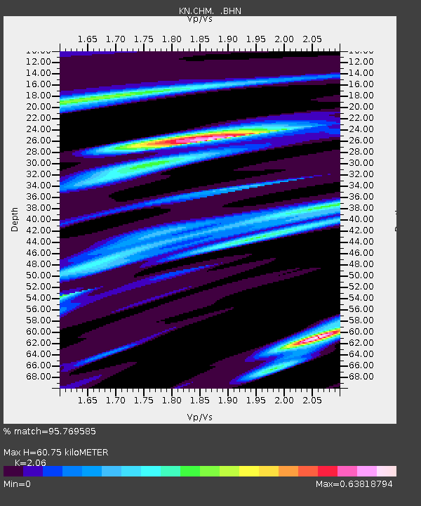
CHM KN.CHM - Earthquake Result Viewer
| Earthquake location: |
Southern Greece |
| Earthquake latitude/longitude: |
36.3/23.2 |
| Earthquake time(UTC): |
2006/01/08 (008) 11:34:55 GMT |
| Earthquake Depth: |
66 km |
| Earthquake Magnitude: |
6.5 MB, 6.7 MW, 6.7 MW |
| Earthquake Catalog/Contributor: |
WHDF/NEIC |
|
| Network: |
KN Kyrgyz Seismic Telemetry Network |
| Station: |
CHM KN.CHM |
| Lat/Lon: |
43.00 N/74.75 E |
| Elevation: |
655 m |
|
| Distance: |
39.7 deg |
| Az: |
64.03 deg |
| Baz: |
278.203 deg |
| Ray Param: |
0.07461952 |
| Estimated Moho Depth: |
60.75 km |
| Estimated Crust Vp/Vs: |
2.06 |
| Assumed Crust Vp: |
6.306 km/s |
| Estimated Crust Vs: |
3.061 km/s |
| Estimated Crust Poisson's Ratio: |
0.35 |
|
| Radial Match: |
95.769585 % |
| Radial Bump: |
231 |
| Transverse Match: |
81.09338 % |
| Transverse Bump: |
400 |
| SOD ConfigId: |
4977 |
| Insert Time: |
2010-03-08 19:16:27.538 +0000 |
| GWidth: |
2.5 |
| Max Bumps: |
400 |
| Tol: |
0.001 |
|

Signal To Noise
| Channel | StoN | STA | LTA |
| KN:CHM: :BHN:20060108T11:41:51.224015Z | 19.513418 | 1.6540589E-6 | 8.4765205E-8 |
| KN:CHM: :BHE:20060108T11:41:51.224015Z | 64.469894 | 5.8213386E-6 | 9.0295465E-8 |
| KN:CHM: :BHZ:20060108T11:41:51.224015Z | 120.01715 | 9.356066E-6 | 7.7956074E-8 |
| Arrivals |
| Ps | 11 SECOND |
| PpPs | 28 SECOND |
| PsPs/PpSs | 39 SECOND |


