You are here: Home > Network List > KN - Kyrgyz Seismic Telemetry Network Stations List
> Station CHM KN.CHM > Earthquake Result Viewer
CHM KN.CHM - Earthquake Result Viewer
| Earthquake location: |
Nicobar Islands, India Region |
| Earthquake latitude/longitude: |
6.4/95.5 |
| Earthquake time(UTC): |
2000/09/09 (253) 06:01:53 GMT |
| Earthquake Depth: |
229 km |
| Earthquake Magnitude: |
5.1 MB, 5.7 MW, 5.7 MW |
| Earthquake Catalog/Contributor: |
WHDF/NEIC |
|
| Network: |
KN Kyrgyz Seismic Telemetry Network |
| Station: |
CHM KN.CHM |
| Lat/Lon: |
43.00 N/74.75 E |
| Elevation: |
655 m |
|
| Distance: |
40.8 deg |
| Az: |
336.588 deg |
| Baz: |
147.437 deg |
| Ray Param: |
0.073287874 |
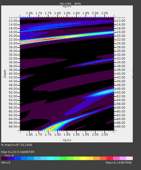
| Estimated Moho Depth: |
23.5 km |
| Estimated Crust Vp/Vs: |
1.60 |
| Assumed Crust Vp: |
6.306 km/s |
| Estimated Crust Vs: |
3.941 km/s |
| Estimated Crust Poisson's Ratio: |
0.18 |
|
| Radial Match: |
97.811806 % |
| Radial Bump: |
134 |
| Transverse Match: |
98.25846 % |
| Transverse Bump: |
133 |
| SOD ConfigId: |
3753 |
| Insert Time: |
2010-03-08 19:16:35.955 +0000 |
| GWidth: |
2.5 |
| Max Bumps: |
400 |
| Tol: |
0.001 |
|
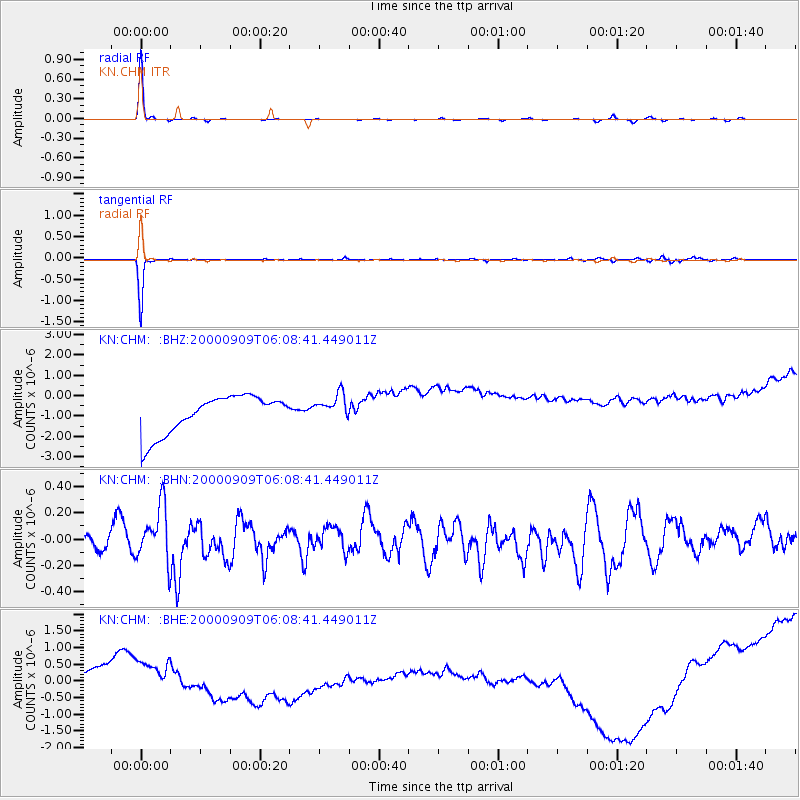
Signal To Noise
| Channel | StoN | STA | LTA |
| KN:CHM: :BHN:20000909T06:08:41.449011Z | 2.3065078 | 2.0890808E-7 | 9.057332E-8 |
| KN:CHM: :BHE:20000909T06:08:41.449011Z | 0.50349814 | 6.8021325E-7 | 1.3509747E-6 |
| KN:CHM: :BHZ:20000909T06:08:41.449011Z | 0.70918936 | 6.627393E-7 | 9.3450257E-7 |
| Arrivals |
| Ps | 2.4 SECOND |
| PpPs | 9.0 SECOND |
| PsPs/PpSs | 11 SECOND |


