You are here: Home > Network List > KN - Kyrgyz Seismic Telemetry Network Stations List
> Station CHM KN.CHM > Earthquake Result Viewer
CHM KN.CHM - Earthquake Result Viewer

| Earthquake location: |
Mindanao, Philippines |
| Earthquake latitude/longitude: |
7.4/126.5 |
| Earthquake time(UTC): |
2000/08/20 (233) 07:55:49 GMT |
| Earthquake Depth: |
174 km |
| Earthquake Magnitude: |
5.5 MB, 5.8 MW, 5.6 MW |
| Earthquake Catalog/Contributor: |
WHDF/NEIC |
|
| Network: |
KN Kyrgyz Seismic Telemetry Network |
| Station: |
CHM KN.CHM |
| Lat/Lon: |
43.00 N/74.75 E |
| Elevation: |
655 m |
|
| Distance: |
57.5 deg |
| Az: |
316.879 deg |
| Baz: |
112.484 deg |
| Ray Param: |
0.06288875 |
| Estimated Moho Depth: |
56.75 km |
| Estimated Crust Vp/Vs: |
2.05 |
| Assumed Crust Vp: |
6.306 km/s |
| Estimated Crust Vs: |
3.084 km/s |
| Estimated Crust Poisson's Ratio: |
0.34 |
|
| Radial Match: |
99.0065 % |
| Radial Bump: |
134 |
| Transverse Match: |
97.58917 % |
| Transverse Bump: |
294 |
| SOD ConfigId: |
3753 |
| Insert Time: |
2010-03-08 19:16:39.452 +0000 |
| GWidth: |
2.5 |
| Max Bumps: |
400 |
| Tol: |
0.001 |
|
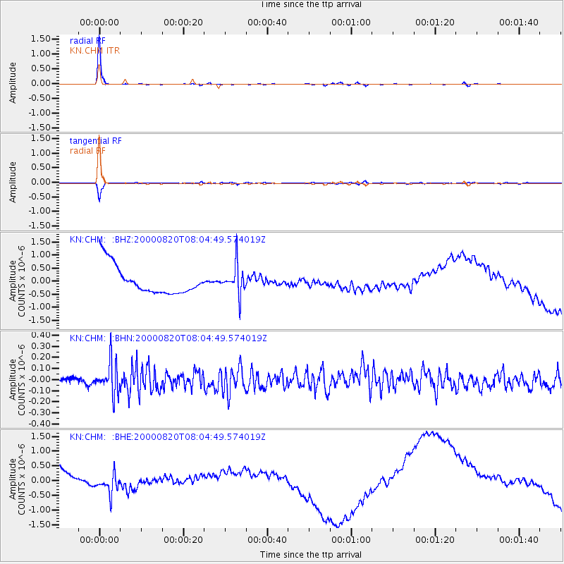
Signal To Noise
| Channel | StoN | STA | LTA |
| KN:CHM: :BHN:20000820T08:04:49.574019Z | 3.2495248 | 1.4862876E-7 | 4.5738613E-8 |
| KN:CHM: :BHE:20000820T08:04:49.574019Z | 0.40471298 | 3.2594107E-7 | 8.053635E-7 |
| KN:CHM: :BHZ:20000820T08:04:49.574019Z | 1.0438825 | 5.714007E-7 | 5.4738024E-7 |
| Arrivals |
| Ps | 9.8 SECOND |
| PpPs | 26 SECOND |
| PsPs/PpSs | 36 SECOND |


