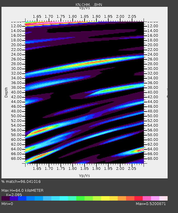
CHM KN.CHM - Earthquake Result Viewer
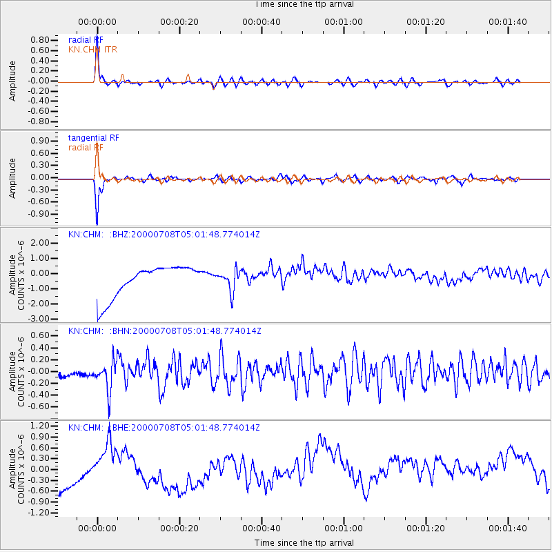
Earthquake location: Southern Sumatra, Indonesia
Earthquake latitude/longitude: -5.4/102.7
Earthquake time(UTC): 2000/07/08 (190) 04:52:55 GMT
Earthquake Depth: 33 km
Earthquake Magnitude: 5.7 MB, 5.7 MS, 5.9 MW, 5.8 MW
Earthquake Catalog/Contributor: WHDF/NEIC
Network: KN Kyrgyz Seismic Telemetry Network
Station: CHM KN.CHM
Lat/Lon: 43.00 N/74.75 E
Elevation: 655 m
Distance: 54.4 deg
Az: 334.995 deg
Baz: 144.997 deg
Ray Param: 0.06539175
Estimated Moho Depth: 64.0 km
Estimated Crust Vp/Vs: 2.10
Assumed Crust Vp: 6.306 km/s
Estimated Crust Vs: 3.01 km/s
Estimated Crust Poisson's Ratio: 0.35
Radial Match: 96.041016 %
Radial Bump: 400
Transverse Match: 94.29132 %
Transverse Bump: 304
SOD ConfigId: 3753
Insert Time: 2010-03-08 19:16:45.321 +0000
GWidth: 2.5
Max Bumps: 400
Tol: 0.001

Signal To Noise

ChannelStoNSTALTA
KN:CHM: :BHN:20000708T05:01:48.774014Z3.6969742.5909839E-77.00839E-8
KN:CHM: :BHE:20000708T05:01:48.774014Z0.20252632.9740005E-71.4684514E-6
KN:CHM: :BHZ:20000708T05:01:48.774014Z0.664660756.843843E-71.0296745E-6
Arrivals
Ps12 SECOND
PpPs30 SECOND
PsPs/PpSs42 SECOND