You are here: Home > Network List > KN - Kyrgyz Seismic Telemetry Network Stations List
> Station CHM KN.CHM > Earthquake Result Viewer
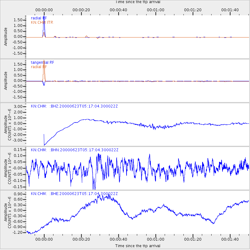
CHM KN.CHM - Earthquake Result Viewer

| Earthquake location: |
New Ireland Region, P.N.G. |
| Earthquake latitude/longitude: |
-5.0/153.7 |
| Earthquake time(UTC): |
2000/06/23 (175) 05:05:01 GMT |
| Earthquake Depth: |
33 km |
| Earthquake Magnitude: |
5.5 MB |
| Earthquake Catalog/Contributor: |
WHDF/NEIC |
|
| Network: |
KN Kyrgyz Seismic Telemetry Network |
| Station: |
CHM KN.CHM |
| Lat/Lon: |
43.00 N/74.75 E |
| Elevation: |
655 m |
|
| Distance: |
85.3 deg |
| Az: |
313.748 deg |
| Baz: |
101.204 deg |
| Ray Param: |
0.044803597 |
| Estimated Moho Depth: |
64.25 km |
| Estimated Crust Vp/Vs: |
1.60 |
| Assumed Crust Vp: |
6.306 km/s |
| Estimated Crust Vs: |
3.941 km/s |
| Estimated Crust Poisson's Ratio: |
0.18 |
|
| Radial Match: |
99.60104 % |
| Radial Bump: |
68 |
| Transverse Match: |
98.49075 % |
| Transverse Bump: |
317 |
| SOD ConfigId: |
3753 |
| Insert Time: |
2010-03-08 19:16:47.079 +0000 |
| GWidth: |
2.5 |
| Max Bumps: |
400 |
| Tol: |
0.001 |
|
Signal To Noise
| Channel | StoN | STA | LTA |
| KN:CHM: :BHN:20000623T05:17:04.300022Z | 0.63796777 | 3.489968E-8 | 5.4704454E-8 |
| KN:CHM: :BHE:20000623T05:17:04.300022Z | 0.9034977 | 1.7751835E-6 | 1.9647903E-6 |
| KN:CHM: :BHZ:20000623T05:17:04.300022Z | 0.8986897 | 1.2404004E-6 | 1.3802321E-6 |
| Arrivals |
| Ps | 6.3 SECOND |
| PpPs | 26 SECOND |
| PsPs/PpSs | 32 SECOND |


