You are here: Home > Network List > KN - Kyrgyz Seismic Telemetry Network Stations List
> Station CHM KN.CHM > Earthquake Result Viewer
CHM KN.CHM - Earthquake Result Viewer
| Earthquake location: |
Luzon, Philippines |
| Earthquake latitude/longitude: |
14.0/120.5 |
| Earthquake time(UTC): |
2000/06/19 (171) 09:34:57 GMT |
| Earthquake Depth: |
115 km |
| Earthquake Magnitude: |
5.7 MB, 5.7 MW, 5.6 MW |
| Earthquake Catalog/Contributor: |
WHDF/NEIC |
|
| Network: |
KN Kyrgyz Seismic Telemetry Network |
| Station: |
CHM KN.CHM |
| Lat/Lon: |
43.00 N/74.75 E |
| Elevation: |
655 m |
|
| Distance: |
48.7 deg |
| Az: |
315.576 deg |
| Baz: |
112.172 deg |
| Ray Param: |
0.06879345 |
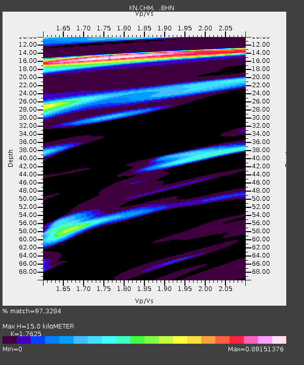
| Estimated Moho Depth: |
15.0 km |
| Estimated Crust Vp/Vs: |
1.76 |
| Assumed Crust Vp: |
6.306 km/s |
| Estimated Crust Vs: |
3.578 km/s |
| Estimated Crust Poisson's Ratio: |
0.26 |
|
| Radial Match: |
97.3284 % |
| Radial Bump: |
283 |
| Transverse Match: |
92.092636 % |
| Transverse Bump: |
400 |
| SOD ConfigId: |
3753 |
| Insert Time: |
2010-03-08 19:16:48.446 +0000 |
| GWidth: |
2.5 |
| Max Bumps: |
400 |
| Tol: |
0.001 |
|
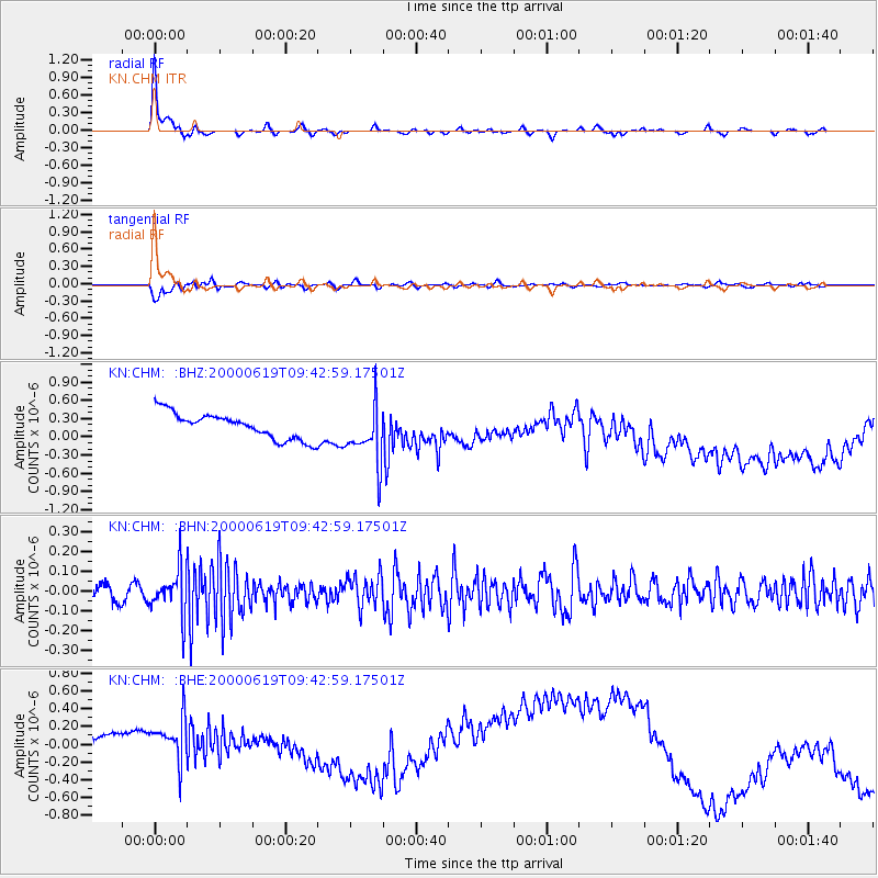
Signal To Noise
| Channel | StoN | STA | LTA |
| KN:CHM: :BHN:20000619T09:42:59.17501Z | 3.2105181 | 1.1297334E-7 | 3.5188506E-8 |
| KN:CHM: :BHE:20000619T09:42:59.17501Z | 1.5095211 | 4.650564E-7 | 3.0808206E-7 |
| KN:CHM: :BHZ:20000619T09:42:59.17501Z | 2.26958 | 4.7809624E-7 | 2.1065408E-7 |
| Arrivals |
| Ps | 1.9 SECOND |
| PpPs | 6.2 SECOND |
| PsPs/PpSs | 8.1 SECOND |


