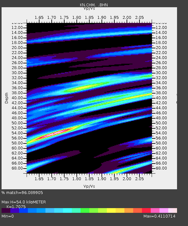
CHM KN.CHM - Earthquake Result Viewer
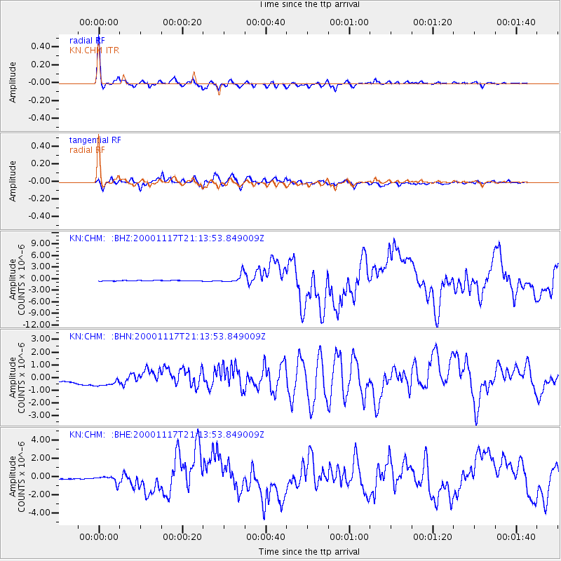
Earthquake location: New Britain Region, P.N.G.
Earthquake latitude/longitude: -5.5/151.8
Earthquake time(UTC): 2000/11/17 (322) 21:01:56 GMT
Earthquake Depth: 33 km
Earthquake Magnitude: 6.2 MB, 8.0 MS, 7.6 MW, 6.9 ME
Earthquake Catalog/Contributor: WHDF/NEIC
Network: KN Kyrgyz Seismic Telemetry Network
Station: CHM KN.CHM
Lat/Lon: 43.00 N/74.75 E
Elevation: 655 m
Distance: 84.3 deg
Az: 314.071 deg
Baz: 102.869 deg
Ray Param: 0.045536146
Estimated Moho Depth: 54.0 km
Estimated Crust Vp/Vs: 1.71
Assumed Crust Vp: 6.306 km/s
Estimated Crust Vs: 3.693 km/s
Estimated Crust Poisson's Ratio: 0.24
Radial Match: 96.089905 %
Radial Bump: 392
Transverse Match: 83.57643 %
Transverse Bump: 400
SOD ConfigId: 3744
Insert Time: 2010-03-08 19:16:51.995 +0000
GWidth: 2.5
Max Bumps: 400
Tol: 0.001

Signal To Noise

ChannelStoNSTALTA
KN:CHM: :BHN:20001117T21:13:53.849009Z1.77512916.294211E-73.5457765E-7
KN:CHM: :BHE:20001117T21:13:53.849009Z1.16743246.161651E-75.277951E-7
KN:CHM: :BHZ:20001117T21:13:53.849009Z17.1493431.2652289E-67.37771E-8
Arrivals
Ps6.2 SECOND
PpPs23 SECOND
PsPs/PpSs29 SECOND