You are here: Home > Network List > KN - Kyrgyz Seismic Telemetry Network Stations List
> Station CHM KN.CHM > Earthquake Result Viewer
CHM KN.CHM - Earthquake Result Viewer
| Earthquake location: |
Halmahera, Indonesia |
| Earthquake latitude/longitude: |
-1.1/129.3 |
| Earthquake time(UTC): |
2000/09/10 (254) 19:06:15 GMT |
| Earthquake Depth: |
33 km |
| Earthquake Magnitude: |
5.9 MB, 6.0 MS, 6.1 MW, 6.1 MW |
| Earthquake Catalog/Contributor: |
WHDF/NEIC |
|
| Network: |
KN Kyrgyz Seismic Telemetry Network |
| Station: |
CHM KN.CHM |
| Lat/Lon: |
43.00 N/74.75 E |
| Elevation: |
655 m |
|
| Distance: |
65.7 deg |
| Az: |
318.993 deg |
| Baz: |
116.593 deg |
| Ray Param: |
0.058067583 |
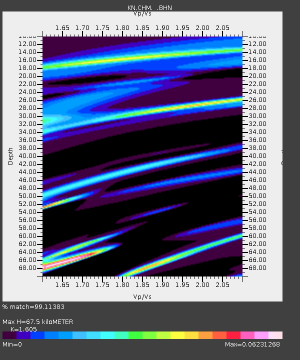
| Estimated Moho Depth: |
67.5 km |
| Estimated Crust Vp/Vs: |
1.61 |
| Assumed Crust Vp: |
6.306 km/s |
| Estimated Crust Vs: |
3.929 km/s |
| Estimated Crust Poisson's Ratio: |
0.18 |
|
| Radial Match: |
99.11383 % |
| Radial Bump: |
78 |
| Transverse Match: |
97.589455 % |
| Transverse Bump: |
175 |
| SOD ConfigId: |
3744 |
| Insert Time: |
2010-03-08 19:17:03.912 +0000 |
| GWidth: |
2.5 |
| Max Bumps: |
400 |
| Tol: |
0.001 |
|
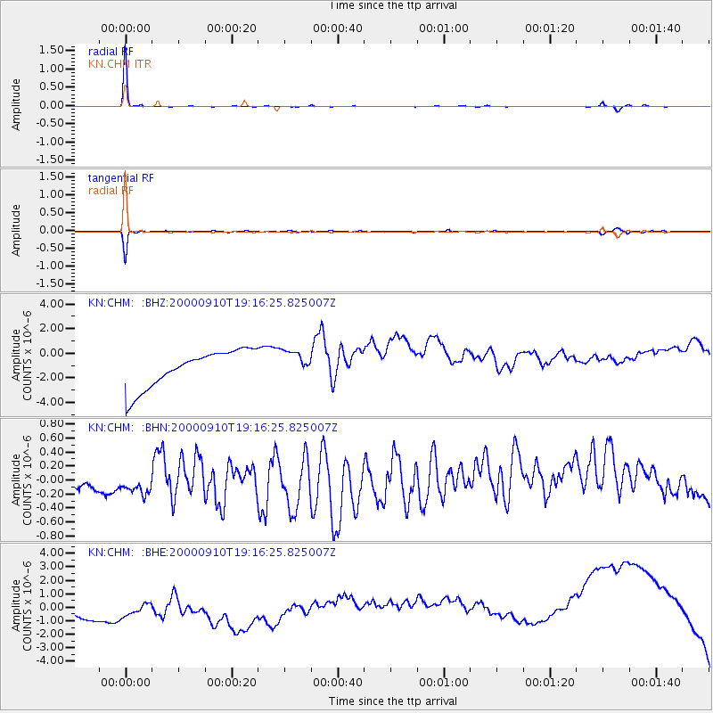
Signal To Noise
| Channel | StoN | STA | LTA |
| KN:CHM: :BHN:20000910T19:16:25.825007Z | 1.0511392 | 4.3257273E-7 | 4.115275E-7 |
| KN:CHM: :BHE:20000910T19:16:25.825007Z | 0.77848846 | 1.6611122E-6 | 2.133766E-6 |
| KN:CHM: :BHZ:20000910T19:16:25.825007Z | 0.72557116 | 1.0994464E-6 | 1.515284E-6 |
| Arrivals |
| Ps | 6.8 SECOND |
| PpPs | 27 SECOND |
| PsPs/PpSs | 33 SECOND |


