You are here: Home > Network List > KN - Kyrgyz Seismic Telemetry Network Stations List
> Station CHM KN.CHM > Earthquake Result Viewer
CHM KN.CHM - Earthquake Result Viewer
| Earthquake location: |
Irian Jaya, Indonesia |
| Earthquake latitude/longitude: |
-3.1/136.1 |
| Earthquake time(UTC): |
2000/08/12 (225) 10:26:15 GMT |
| Earthquake Depth: |
33 km |
| Earthquake Magnitude: |
5.6 MB, 5.7 MS, 6.0 MW, 5.9 MW |
| Earthquake Catalog/Contributor: |
WHDF/NEIC |
|
| Network: |
KN Kyrgyz Seismic Telemetry Network |
| Station: |
CHM KN.CHM |
| Lat/Lon: |
43.00 N/74.75 E |
| Elevation: |
655 m |
|
| Distance: |
71.6 deg |
| Az: |
317.28 deg |
| Baz: |
112.571 deg |
| Ray Param: |
0.054142676 |
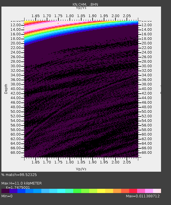
| Estimated Moho Depth: |
11.0 km |
| Estimated Crust Vp/Vs: |
1.75 |
| Assumed Crust Vp: |
6.306 km/s |
| Estimated Crust Vs: |
3.609 km/s |
| Estimated Crust Poisson's Ratio: |
0.26 |
|
| Radial Match: |
99.52325 % |
| Radial Bump: |
38 |
| Transverse Match: |
98.641304 % |
| Transverse Bump: |
109 |
| SOD ConfigId: |
3744 |
| Insert Time: |
2010-03-08 19:17:08.706 +0000 |
| GWidth: |
2.5 |
| Max Bumps: |
400 |
| Tol: |
0.001 |
|
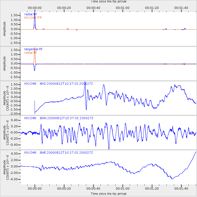
Signal To Noise
| Channel | StoN | STA | LTA |
| KN:CHM: :BHN:20000812T10:37:03.200027Z | 3.0794306 | 9.58316E-8 | 3.111991E-8 |
| KN:CHM: :BHE:20000812T10:37:03.200027Z | 2.016967 | 1.2837488E-6 | 6.3647485E-7 |
| KN:CHM: :BHZ:20000812T10:37:03.200027Z | 2.6000824 | 1.1032129E-6 | 4.242992E-7 |
| Arrivals |
| Ps | 1.3 SECOND |
| PpPs | 4.6 SECOND |
| PsPs/PpSs | 6.0 SECOND |


