You are here: Home > Network List > CN - Canadian National Seismograph Network Stations List
> Station INK INUVIK, NT > Earthquake Result Viewer
INK INUVIK, NT - Earthquake Result Viewer
*The percent match for this event was below the threshold and hence no stack was calculated.
| Earthquake location: |
North Of Honduras |
| Earthquake latitude/longitude: |
16.9/-85.7 |
| Earthquake time(UTC): |
2020/04/16 (107) 08:04:37 GMT |
| Earthquake Depth: |
10 km |
| Earthquake Magnitude: |
6.0 mww |
| Earthquake Catalog/Contributor: |
NEIC PDE/us |
|
| Network: |
CN Canadian National Seismograph Network |
| Station: |
INK INUVIK, NT |
| Lat/Lon: |
68.31 N/133.53 W |
| Elevation: |
44 m |
|
| Distance: |
59.5 deg |
| Az: |
341.351 deg |
| Baz: |
124.588 deg |
| Ray Param: |
$rayparam |
*The percent match for this event was below the threshold and hence was not used in the summary stack. |
|
| Radial Match: |
53.304787 % |
| Radial Bump: |
400 |
| Transverse Match: |
56.529392 % |
| Transverse Bump: |
400 |
| SOD ConfigId: |
21166931 |
| Insert Time: |
2020-04-30 08:14:44.909 +0000 |
| GWidth: |
2.5 |
| Max Bumps: |
400 |
| Tol: |
0.001 |
|
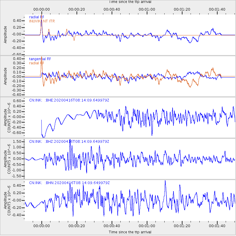
Signal To Noise
| Channel | StoN | STA | LTA |
| CN:INK: :BHZ:20200416T08:14:09.649979Z | 1.9006349 | 2.7219738E-7 | 1.4321394E-7 |
| CN:INK: :BHN:20200416T08:14:09.649979Z | 1.1605633 | 1.1193648E-7 | 9.645012E-8 |
| CN:INK: :BHE:20200416T08:14:09.649979Z | 1.2347184 | 3.1615164E-7 | 2.560516E-7 |
| Arrivals |
| Ps | |
| PpPs | |
| PsPs/PpSs | |


