You are here: Home > Network List > CN - Canadian National Seismograph Network Stations List
> Station MGRB Mount Grey, BC, CA > Earthquake Result Viewer
MGRB Mount Grey, BC, CA - Earthquake Result Viewer
| Earthquake location: |
North Of Honduras |
| Earthquake latitude/longitude: |
16.9/-85.7 |
| Earthquake time(UTC): |
2020/04/16 (107) 08:04:37 GMT |
| Earthquake Depth: |
10 km |
| Earthquake Magnitude: |
6.0 mww |
| Earthquake Catalog/Contributor: |
NEIC PDE/us |
|
| Network: |
CN Canadian National Seismograph Network |
| Station: |
MGRB Mount Grey, BC, CA |
| Lat/Lon: |
49.00 N/124.70 W |
| Elevation: |
1310 m |
|
| Distance: |
44.9 deg |
| Az: |
324.087 deg |
| Baz: |
121.514 deg |
| Ray Param: |
0.071607284 |
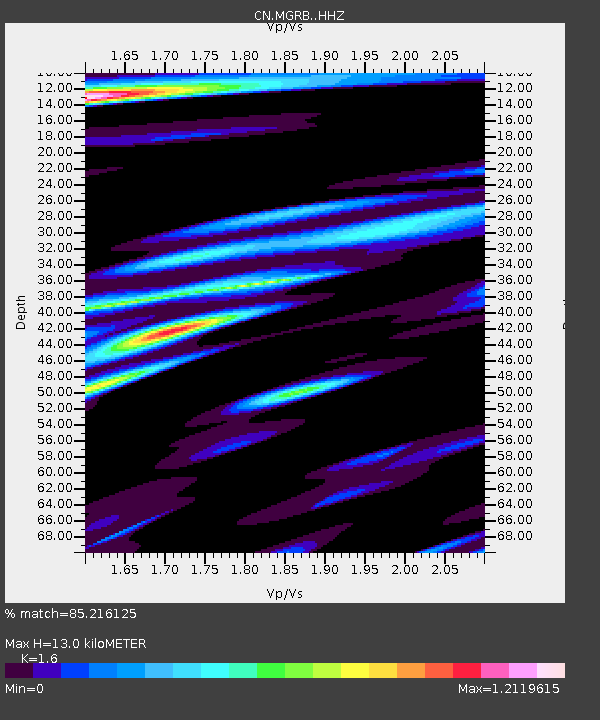
| Estimated Moho Depth: |
13.0 km |
| Estimated Crust Vp/Vs: |
1.60 |
| Assumed Crust Vp: |
6.391 km/s |
| Estimated Crust Vs: |
3.994 km/s |
| Estimated Crust Poisson's Ratio: |
0.18 |
|
| Radial Match: |
85.216125 % |
| Radial Bump: |
400 |
| Transverse Match: |
70.09645 % |
| Transverse Bump: |
400 |
| SOD ConfigId: |
21166931 |
| Insert Time: |
2020-04-30 08:15:01.514 +0000 |
| GWidth: |
2.5 |
| Max Bumps: |
400 |
| Tol: |
0.001 |
|

Signal To Noise
| Channel | StoN | STA | LTA |
| CN:MGRB: :HHZ:20200416T08:12:21.699997Z | 5.5394835 | 5.1072595E-7 | 9.219739E-8 |
| CN:MGRB: :HHN:20200416T08:12:21.699997Z | 2.206733 | 2.724906E-7 | 1.2348146E-7 |
| CN:MGRB: :HHE:20200416T08:12:21.699997Z | 3.092736 | 3.0753642E-7 | 9.94383E-8 |
| Arrivals |
| Ps | 1.3 SECOND |
| PpPs | 4.9 SECOND |
| PsPs/PpSs | 6.2 SECOND |


