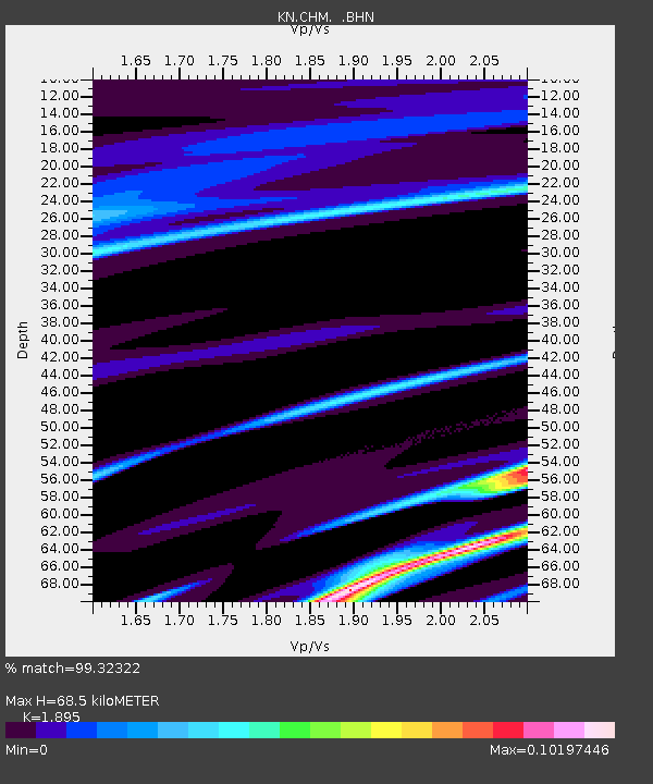
CHM KN.CHM - Earthquake Result Viewer
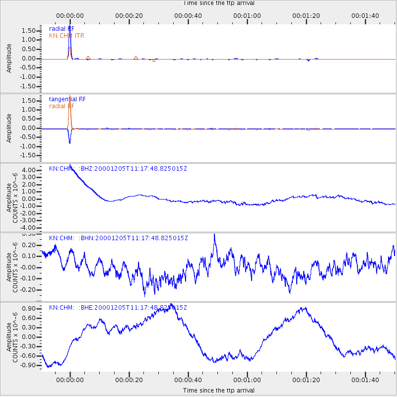
Earthquake location: Talaud Islands, Indonesia
Earthquake latitude/longitude: 4.2/126.4
Earthquake time(UTC): 2000/12/05 (340) 11:08:25 GMT
Earthquake Depth: 101 km
Earthquake Magnitude: 5.5 MB, 5.1 MS, 5.8 MW, 5.7 MW
Earthquake Catalog/Contributor: WHDF/NEIC
Network: KN Kyrgyz Seismic Telemetry Network
Station: CHM KN.CHM
Lat/Lon: 43.00 N/74.75 E
Elevation: 655 m
Distance: 59.8 deg
Az: 318.227 deg
Baz: 115.095 deg
Ray Param: 0.061673027
Estimated Moho Depth: 68.5 km
Estimated Crust Vp/Vs: 1.89
Assumed Crust Vp: 6.306 km/s
Estimated Crust Vs: 3.328 km/s
Estimated Crust Poisson's Ratio: 0.31
Radial Match: 99.32322 %
Radial Bump: 77
Transverse Match: 95.6502 %
Transverse Bump: 108
SOD ConfigId: 3753
Insert Time: 2010-03-08 19:17:59.892 +0000
GWidth: 2.5
Max Bumps: 400
Tol: 0.001

Signal To Noise

ChannelStoNSTALTA
KN:CHM: :BHN:20001205T11:17:48.825015Z0.60104145.6518587E-89.4034434E-8
KN:CHM: :BHE:20001205T11:17:48.825015Z0.77972911.5447906E-61.981189E-6
KN:CHM: :BHZ:20001205T11:17:48.825015Z0.79959831.0692854E-61.3372783E-6
Arrivals
Ps10 SECOND
PpPs30 SECOND
PsPs/PpSs40 SECOND