You are here: Home > Network List > N4 - Central and EAstern US Network Stations List
> Station E62A Clayton Lake, ME, USA > Earthquake Result Viewer
E62A Clayton Lake, ME, USA - Earthquake Result Viewer
| Earthquake location: |
North Of Honduras |
| Earthquake latitude/longitude: |
16.9/-85.7 |
| Earthquake time(UTC): |
2020/04/16 (107) 08:04:37 GMT |
| Earthquake Depth: |
10 km |
| Earthquake Magnitude: |
6.0 mww |
| Earthquake Catalog/Contributor: |
NEIC PDE/us |
|
| Network: |
N4 Central and EAstern US Network |
| Station: |
E62A Clayton Lake, ME, USA |
| Lat/Lon: |
46.62 N/69.52 W |
| Elevation: |
356 m |
|
| Distance: |
32.5 deg |
| Az: |
20.95 deg |
| Baz: |
209.771 deg |
| Ray Param: |
0.07863501 |
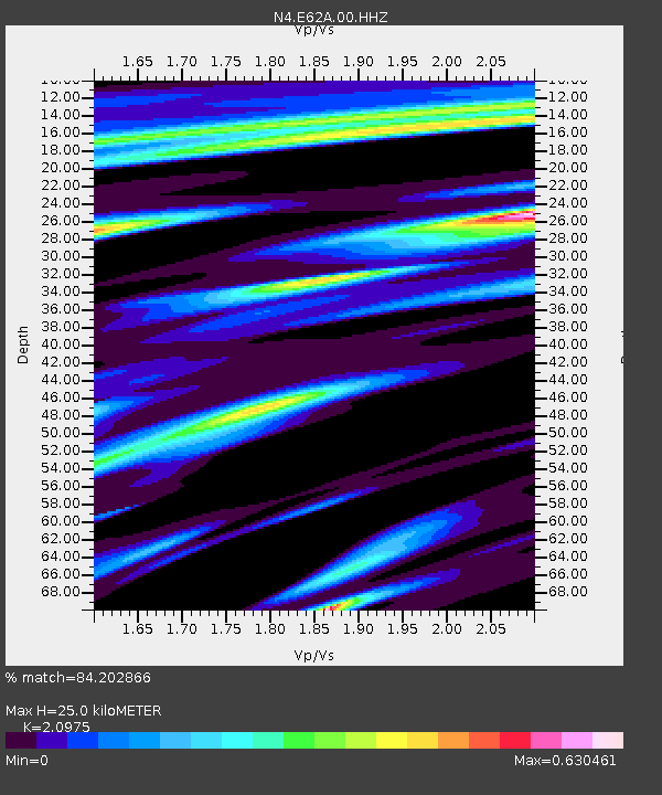
| Estimated Moho Depth: |
25.0 km |
| Estimated Crust Vp/Vs: |
2.10 |
| Assumed Crust Vp: |
6.419 km/s |
| Estimated Crust Vs: |
3.06 km/s |
| Estimated Crust Poisson's Ratio: |
0.35 |
|
| Radial Match: |
84.202866 % |
| Radial Bump: |
260 |
| Transverse Match: |
55.441402 % |
| Transverse Bump: |
400 |
| SOD ConfigId: |
21166931 |
| Insert Time: |
2020-04-30 08:18:48.885 +0000 |
| GWidth: |
2.5 |
| Max Bumps: |
400 |
| Tol: |
0.001 |
|

Signal To Noise
| Channel | StoN | STA | LTA |
| N4:E62A:00:HHZ:20200416T08:10:37.669998Z | 11.567234 | 2.27472E-6 | 1.9665201E-7 |
| N4:E62A:00:HH1:20200416T08:10:37.669998Z | 9.284294 | 1.458258E-6 | 1.570672E-7 |
| N4:E62A:00:HH2:20200416T08:10:37.669998Z | 3.534294 | 7.7915087E-7 | 2.2045447E-7 |
| Arrivals |
| Ps | 4.6 SECOND |
| PpPs | 11 SECOND |
| PsPs/PpSs | 16 SECOND |


