You are here: Home > Network List > KN - Kyrgyz Seismic Telemetry Network Stations List
> Station CHM KN.CHM > Earthquake Result Viewer
CHM KN.CHM - Earthquake Result Viewer
| Earthquake location: |
Bismarck Sea |
| Earthquake latitude/longitude: |
-3.1/148.3 |
| Earthquake time(UTC): |
2000/12/13 (348) 06:10:22 GMT |
| Earthquake Depth: |
33 km |
| Earthquake Magnitude: |
5.1 MB, 5.6 MS, 5.8 MW |
| Earthquake Catalog/Contributor: |
WHDF/NEIC |
|
| Network: |
KN Kyrgyz Seismic Telemetry Network |
| Station: |
CHM KN.CHM |
| Lat/Lon: |
43.00 N/74.75 E |
| Elevation: |
655 m |
|
| Distance: |
80.2 deg |
| Az: |
314.422 deg |
| Baz: |
103.568 deg |
| Ray Param: |
0.048411716 |
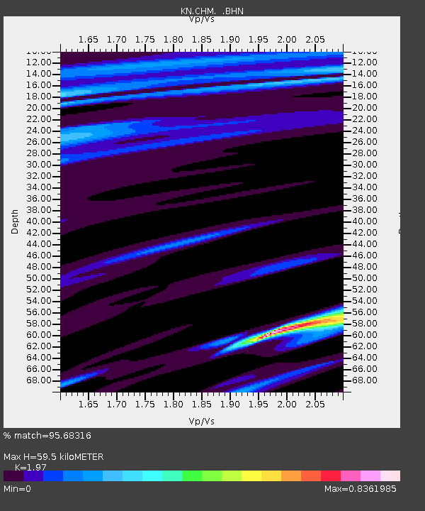
| Estimated Moho Depth: |
59.5 km |
| Estimated Crust Vp/Vs: |
1.97 |
| Assumed Crust Vp: |
6.306 km/s |
| Estimated Crust Vs: |
3.201 km/s |
| Estimated Crust Poisson's Ratio: |
0.33 |
|
| Radial Match: |
95.68316 % |
| Radial Bump: |
185 |
| Transverse Match: |
85.13984 % |
| Transverse Bump: |
400 |
| SOD ConfigId: |
3753 |
| Insert Time: |
2010-03-08 19:18:03.689 +0000 |
| GWidth: |
2.5 |
| Max Bumps: |
400 |
| Tol: |
0.001 |
|

Signal To Noise
| Channel | StoN | STA | LTA |
| KN:CHM: :BHN:20001213T06:21:58.474004Z | 1.2307186 | 1.6726742E-7 | 1.3591037E-7 |
| KN:CHM: :BHE:20001213T06:21:58.474004Z | 0.6293957 | 3.6016684E-7 | 5.722423E-7 |
| KN:CHM: :BHZ:20001213T06:21:58.474004Z | 0.72683054 | 2.9614466E-7 | 4.0744666E-7 |
| Arrivals |
| Ps | 9.4 SECOND |
| PpPs | 27 SECOND |
| PsPs/PpSs | 37 SECOND |


