You are here: Home > Network List > ON - RSIS-Rede Sismografica do Sul e Sudeste Observatorio Nacional, Brazil Stations List
> Station ANA01 "OBSN: [ANA01] Lindo Horizonte, BA" > Earthquake Result Viewer
ANA01 "OBSN: [ANA01] Lindo Horizonte, BA" - Earthquake Result Viewer
| Earthquake location: |
North Of Honduras |
| Earthquake latitude/longitude: |
16.9/-85.7 |
| Earthquake time(UTC): |
2020/04/16 (107) 08:04:37 GMT |
| Earthquake Depth: |
10 km |
| Earthquake Magnitude: |
6.0 mww |
| Earthquake Catalog/Contributor: |
NEIC PDE/us |
|
| Network: |
ON RSIS-Rede Sismografica do Sul e Sudeste Observatorio Nacional, Brazil |
| Station: |
ANA01 "OBSN: [ANA01] Lindo Horizonte, BA" |
| Lat/Lon: |
14.53 S/40.75 W |
| Elevation: |
741 m |
|
| Distance: |
54.3 deg |
| Az: |
122.561 deg |
| Baz: |
303.587 deg |
| Ray Param: |
0.06555347 |
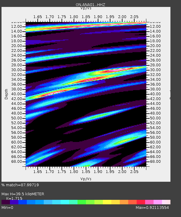
| Estimated Moho Depth: |
39.5 km |
| Estimated Crust Vp/Vs: |
1.72 |
| Assumed Crust Vp: |
6.459 km/s |
| Estimated Crust Vs: |
3.766 km/s |
| Estimated Crust Poisson's Ratio: |
0.24 |
|
| Radial Match: |
87.99719 % |
| Radial Bump: |
400 |
| Transverse Match: |
73.40469 % |
| Transverse Bump: |
400 |
| SOD ConfigId: |
21166931 |
| Insert Time: |
2020-04-30 08:19:57.948 +0000 |
| GWidth: |
2.5 |
| Max Bumps: |
400 |
| Tol: |
0.001 |
|

Signal To Noise
| Channel | StoN | STA | LTA |
| ON:ANA01: :HHZ:20200416T08:13:32.828018Z | 2.5517635 | 4.3070722E-7 | 1.6878806E-7 |
| ON:ANA01: :HHN:20200416T08:13:32.828018Z | 0.9884884 | 1.2370462E-7 | 1.2514525E-7 |
| ON:ANA01: :HHE:20200416T08:13:32.828018Z | 2.4055603 | 2.7885145E-7 | 1.1591954E-7 |
| Arrivals |
| Ps | 4.6 SECOND |
| PpPs | 16 SECOND |
| PsPs/PpSs | 20 SECOND |


