You are here: Home > Network List > TA - USArray Transportable Network (new EarthScope stations) Stations List
> Station C27K Jago River, AK, USA > Earthquake Result Viewer
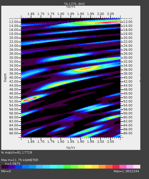
C27K Jago River, AK, USA - Earthquake Result Viewer
| Earthquake location: |
North Of Honduras |
| Earthquake latitude/longitude: |
16.9/-85.7 |
| Earthquake time(UTC): |
2020/04/16 (107) 08:04:37 GMT |
| Earthquake Depth: |
10 km |
| Earthquake Magnitude: |
6.0 mww |
| Earthquake Catalog/Contributor: |
NEIC PDE/us |
|
| Network: |
TA USArray Transportable Network (new EarthScope stations) |
| Station: |
C27K Jago River, AK, USA |
| Lat/Lon: |
69.63 N/143.71 W |
| Elevation: |
392 m |
|
| Distance: |
63.3 deg |
| Az: |
340.589 deg |
| Baz: |
114.72 deg |
| Ray Param: |
0.059649345 |
| Estimated Moho Depth: |
11.75 km |
| Estimated Crust Vp/Vs: |
2.10 |
| Assumed Crust Vp: |
6.522 km/s |
| Estimated Crust Vs: |
3.109 km/s |
| Estimated Crust Poisson's Ratio: |
0.35 |
|
| Radial Match: |
91.17719 % |
| Radial Bump: |
400 |
| Transverse Match: |
84.97292 % |
| Transverse Bump: |
400 |
| SOD ConfigId: |
21166931 |
| Insert Time: |
2020-04-30 08:21:59.553 +0000 |
| GWidth: |
2.5 |
| Max Bumps: |
400 |
| Tol: |
0.001 |
|

Signal To Noise
| Channel | StoN | STA | LTA |
| TA:C27K: :BHZ:20200416T08:14:35.599991Z | 4.33566 | 2.7932487E-7 | 6.4424995E-8 |
| TA:C27K: :BHN:20200416T08:14:35.599991Z | 1.2193924 | 9.3675006E-8 | 7.6821046E-8 |
| TA:C27K: :BHE:20200416T08:14:35.599991Z | 1.4731865 | 7.671692E-8 | 5.20755E-8 |
| Arrivals |
| Ps | 2.1 SECOND |
| PpPs | 5.4 SECOND |
| PsPs/PpSs | 7.4 SECOND |


