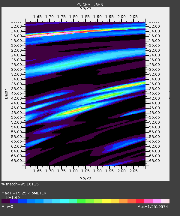
CHM KN.CHM - Earthquake Result Viewer
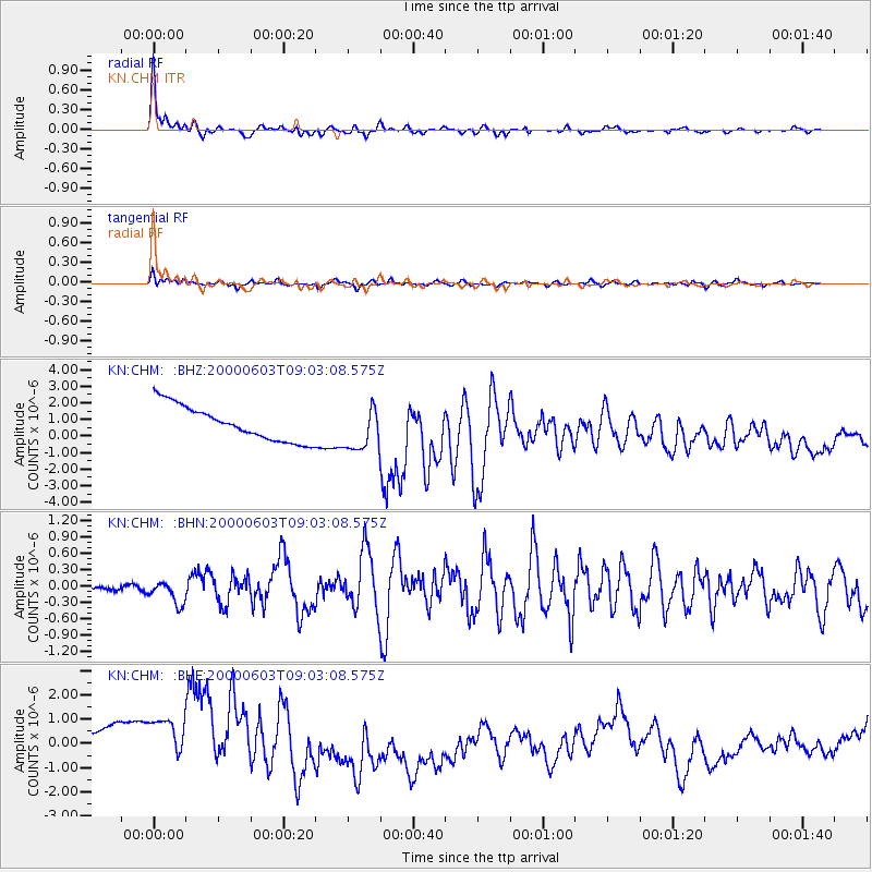
Earthquake location: Near East Coast Of Honshu, Japan
Earthquake latitude/longitude: 35.6/140.5
Earthquake time(UTC): 2000/06/03 (155) 08:54:49 GMT
Earthquake Depth: 62 km
Earthquake Magnitude: 5.6 MB, 5.6 MS, 6.1 MW, 6.1 MW
Earthquake Catalog/Contributor: WHDF/NEIC
Network: KN Kyrgyz Seismic Telemetry Network
Station: CHM KN.CHM
Lat/Lon: 43.00 N/74.75 E
Elevation: 655 m
Distance: 50.3 deg
Az: 299.571 deg
Baz: 75.172 deg
Ray Param: 0.06800139
Estimated Moho Depth: 15.25 km
Estimated Crust Vp/Vs: 1.69
Assumed Crust Vp: 6.306 km/s
Estimated Crust Vs: 3.731 km/s
Estimated Crust Poisson's Ratio: 0.23
Radial Match: 95.16125 %
Radial Bump: 307
Transverse Match: 84.43561 %
Transverse Bump: 400
SOD ConfigId: 3744
Insert Time: 2010-03-08 19:18:34.137 +0000
GWidth: 2.5
Max Bumps: 400
Tol: 0.001

Signal To Noise

ChannelStoNSTALTA
KN:CHM: :BHN:20000603T09:03:08.575Z5.146962.0446716E-73.9725812E-8
KN:CHM: :BHE:20000603T09:03:08.575Z1.2702821.849904E-61.456294E-6
KN:CHM: :BHZ:20000603T09:03:08.575Z1.28106051.3366354E-61.043382E-6
Arrivals
Ps1.8 SECOND
PpPs6.1 SECOND
PsPs/PpSs7.9 SECOND