You are here: Home > Network List > TA - USArray Transportable Network (new EarthScope stations) Stations List
> Station F21K Alatna River, AK, USA > Earthquake Result Viewer
F21K Alatna River, AK, USA - Earthquake Result Viewer
| Earthquake location: |
North Of Honduras |
| Earthquake latitude/longitude: |
16.9/-85.7 |
| Earthquake time(UTC): |
2020/04/16 (107) 08:04:37 GMT |
| Earthquake Depth: |
10 km |
| Earthquake Magnitude: |
6.0 mww |
| Earthquake Catalog/Contributor: |
NEIC PDE/us |
|
| Network: |
TA USArray Transportable Network (new EarthScope stations) |
| Station: |
F21K Alatna River, AK, USA |
| Lat/Lon: |
67.22 N/153.48 W |
| Elevation: |
597 m |
|
| Distance: |
65.9 deg |
| Az: |
336.751 deg |
| Baz: |
103.992 deg |
| Ray Param: |
0.057939213 |
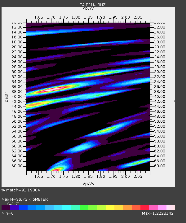
| Estimated Moho Depth: |
36.75 km |
| Estimated Crust Vp/Vs: |
1.71 |
| Assumed Crust Vp: |
6.455 km/s |
| Estimated Crust Vs: |
3.775 km/s |
| Estimated Crust Poisson's Ratio: |
0.24 |
|
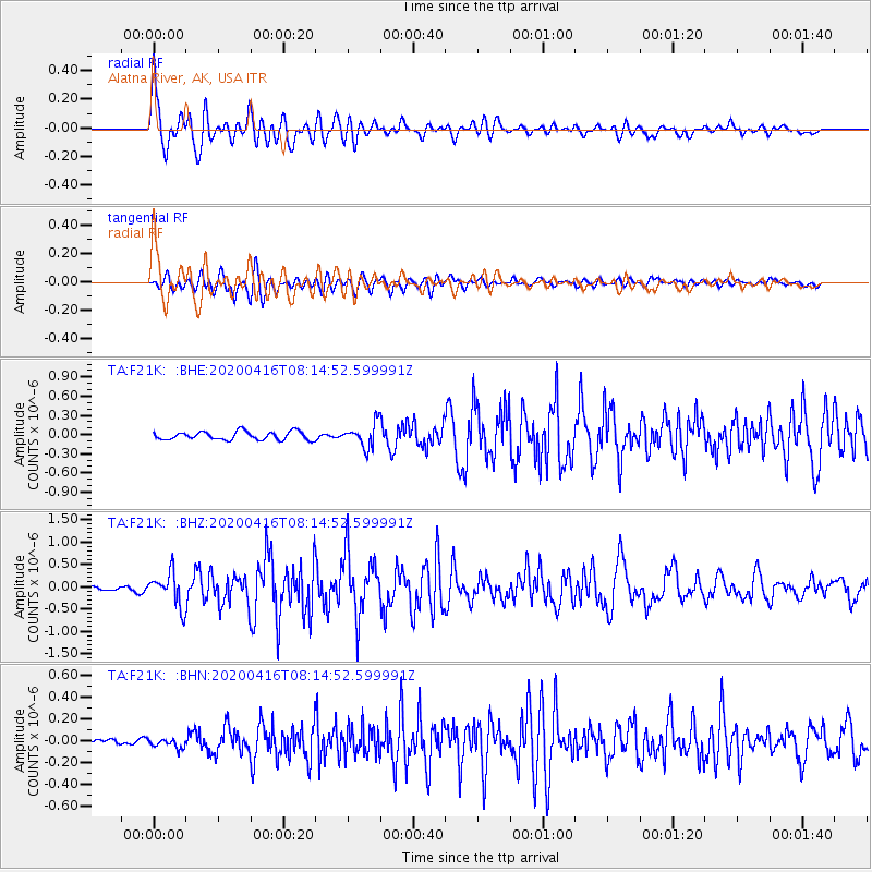
| Radial Match: |
91.19004 % |
| Radial Bump: |
400 |
| Transverse Match: |
79.03792 % |
| Transverse Bump: |
400 |
| SOD ConfigId: |
21166931 |
| Insert Time: |
2020-04-30 08:22:36.906 +0000 |
| GWidth: |
2.5 |
| Max Bumps: |
400 |
| Tol: |
0.001 |
|
Signal To Noise
| Channel | StoN | STA | LTA |
| TA:F21K: :BHZ:20200416T08:14:52.599991Z | 8.806373 | 3.7393448E-7 | 4.2461807E-8 |
| TA:F21K: :BHN:20200416T08:14:52.599991Z | 0.9458066 | 4.180884E-8 | 4.4204423E-8 |
| TA:F21K: :BHE:20200416T08:14:52.599991Z | 2.8460681 | 1.8446798E-7 | 6.4815026E-8 |
| Arrivals |
| Ps | 4.2 SECOND |
| PpPs | 15 SECOND |
| PsPs/PpSs | 19 SECOND |


