You are here: Home > Network List > TA - USArray Transportable Network (new EarthScope stations) Stations List
> Station G31M Satah River, YT, CAN > Earthquake Result Viewer
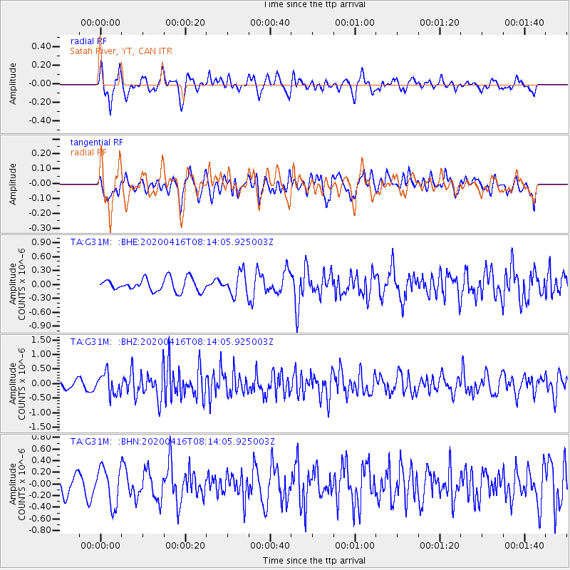
G31M Satah River, YT, CAN - Earthquake Result Viewer
*The percent match for this event was below the threshold and hence no stack was calculated.
| Earthquake location: |
North Of Honduras |
| Earthquake latitude/longitude: |
16.9/-85.7 |
| Earthquake time(UTC): |
2020/04/16 (107) 08:04:37 GMT |
| Earthquake Depth: |
10 km |
| Earthquake Magnitude: |
6.0 mww |
| Earthquake Catalog/Contributor: |
NEIC PDE/us |
|
| Network: |
TA USArray Transportable Network (new EarthScope stations) |
| Station: |
G31M Satah River, YT, CAN |
| Lat/Lon: |
66.92 N/134.27 W |
| Elevation: |
61 m |
|
| Distance: |
59.0 deg |
| Az: |
339.822 deg |
| Baz: |
123.117 deg |
| Ray Param: |
$rayparam |
*The percent match for this event was below the threshold and hence was not used in the summary stack. |
|
| Radial Match: |
57.120377 % |
| Radial Bump: |
400 |
| Transverse Match: |
63.08124 % |
| Transverse Bump: |
400 |
| SOD ConfigId: |
21166931 |
| Insert Time: |
2020-04-30 08:23:05.034 +0000 |
| GWidth: |
2.5 |
| Max Bumps: |
400 |
| Tol: |
0.001 |
|
Signal To Noise
| Channel | StoN | STA | LTA |
| TA:G31M: :BHZ:20200416T08:14:05.925003Z | 3.2769277 | 3.7109032E-7 | 1.1324337E-7 |
| TA:G31M: :BHN:20200416T08:14:05.925003Z | 2.4627829 | 3.2968478E-7 | 1.3386678E-7 |
| TA:G31M: :BHE:20200416T08:14:05.925003Z | 1.8102875 | 2.4648884E-7 | 1.3616005E-7 |
| Arrivals |
| Ps | |
| PpPs | |
| PsPs/PpSs | |


