You are here: Home > Network List > TA - USArray Transportable Network (new EarthScope stations) Stations List
> Station H18K Honhosa River, AK, USA > Earthquake Result Viewer
H18K Honhosa River, AK, USA - Earthquake Result Viewer
| Earthquake location: |
North Of Honduras |
| Earthquake latitude/longitude: |
16.9/-85.7 |
| Earthquake time(UTC): |
2020/04/16 (107) 08:04:37 GMT |
| Earthquake Depth: |
10 km |
| Earthquake Magnitude: |
6.0 mww |
| Earthquake Catalog/Contributor: |
NEIC PDE/us |
|
| Network: |
TA USArray Transportable Network (new EarthScope stations) |
| Station: |
H18K Honhosa River, AK, USA |
| Lat/Lon: |
65.15 N/158.36 W |
| Elevation: |
494 m |
|
| Distance: |
67.5 deg |
| Az: |
334.113 deg |
| Baz: |
98.488 deg |
| Ray Param: |
0.056939375 |
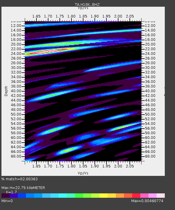
| Estimated Moho Depth: |
22.75 km |
| Estimated Crust Vp/Vs: |
1.70 |
| Assumed Crust Vp: |
6.1 km/s |
| Estimated Crust Vs: |
3.588 km/s |
| Estimated Crust Poisson's Ratio: |
0.24 |
|
| Radial Match: |
82.88363 % |
| Radial Bump: |
400 |
| Transverse Match: |
70.13222 % |
| Transverse Bump: |
400 |
| SOD ConfigId: |
21166931 |
| Insert Time: |
2020-04-30 08:23:08.492 +0000 |
| GWidth: |
2.5 |
| Max Bumps: |
400 |
| Tol: |
0.001 |
|

Signal To Noise
| Channel | StoN | STA | LTA |
| TA:H18K: :BHZ:20200416T08:15:02.399979Z | 6.6120963 | 4.3932457E-7 | 6.644256E-8 |
| TA:H18K: :BHN:20200416T08:15:02.399979Z | 2.067098 | 1.1701773E-7 | 5.660967E-8 |
| TA:H18K: :BHE:20200416T08:15:02.399979Z | 1.542041 | 1.2699289E-7 | 8.235377E-8 |
| Arrivals |
| Ps | 2.7 SECOND |
| PpPs | 9.7 SECOND |
| PsPs/PpSs | 12 SECOND |


