You are here: Home > Network List > KN - Kyrgyz Seismic Telemetry Network Stations List
> Station CHM KN.CHM > Earthquake Result Viewer
CHM KN.CHM - Earthquake Result Viewer
| Earthquake location: |
Off East Coast Of Kamchatka |
| Earthquake latitude/longitude: |
52.1/159.5 |
| Earthquake time(UTC): |
1999/03/08 (067) 12:25:48 GMT |
| Earthquake Depth: |
57 km |
| Earthquake Magnitude: |
5.7 MB, 6.9 MW, 6.8 MW |
| Earthquake Catalog/Contributor: |
WHDF/NEIC |
|
| Network: |
KN Kyrgyz Seismic Telemetry Network |
| Station: |
CHM KN.CHM |
| Lat/Lon: |
43.00 N/74.75 E |
| Elevation: |
655 m |
|
| Distance: |
54.8 deg |
| Az: |
296.669 deg |
| Baz: |
48.771 deg |
| Ray Param: |
0.06504097 |
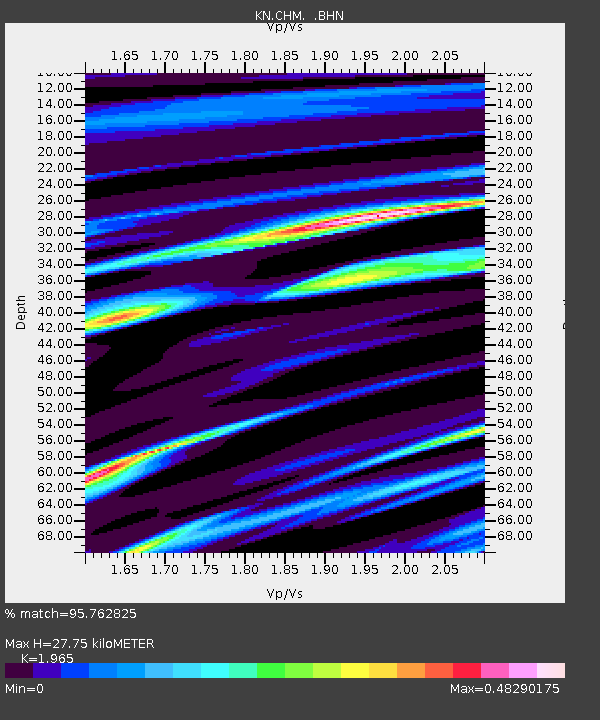
| Estimated Moho Depth: |
27.75 km |
| Estimated Crust Vp/Vs: |
1.97 |
| Assumed Crust Vp: |
6.306 km/s |
| Estimated Crust Vs: |
3.209 km/s |
| Estimated Crust Poisson's Ratio: |
0.33 |
|
| Radial Match: |
95.762825 % |
| Radial Bump: |
280 |
| Transverse Match: |
62.8001 % |
| Transverse Bump: |
354 |
| SOD ConfigId: |
4480 |
| Insert Time: |
2010-03-08 19:18:50.649 +0000 |
| GWidth: |
2.5 |
| Max Bumps: |
400 |
| Tol: |
0.001 |
|

Signal To Noise
| Channel | StoN | STA | LTA |
| KN:CHM: :BHN:19990308T12:34:42.825022Z | 7.1092114 | 4.388955E-6 | 6.173617E-7 |
| KN:CHM: :BHE:19990308T12:34:42.825022Z | 29.358038 | 1.1699213E-6 | 3.985012E-8 |
| KN:CHM: :BHZ:19990308T12:34:42.825022Z | 2.9327638 | 2.7017747E-6 | 9.2123844E-7 |
| Arrivals |
| Ps | 4.4 SECOND |
| PpPs | 12 SECOND |
| PsPs/PpSs | 17 SECOND |


