You are here: Home > Network List > TD - TransAlta Monitoring Network Stations List
> Station TD009 Z > Earthquake Result Viewer
TD009 Z - Earthquake Result Viewer
| Earthquake location: |
North Of Honduras |
| Earthquake latitude/longitude: |
16.9/-85.7 |
| Earthquake time(UTC): |
2020/04/16 (107) 08:04:37 GMT |
| Earthquake Depth: |
10 km |
| Earthquake Magnitude: |
6.0 mww |
| Earthquake Catalog/Contributor: |
NEIC PDE/us |
|
| Network: |
TD TransAlta Monitoring Network |
| Station: |
TD009 Z |
| Lat/Lon: |
52.32 N/116.32 W |
| Elevation: |
1335 m |
|
| Distance: |
42.8 deg |
| Az: |
332.589 deg |
| Baz: |
134.117 deg |
| Ray Param: |
0.07298368 |
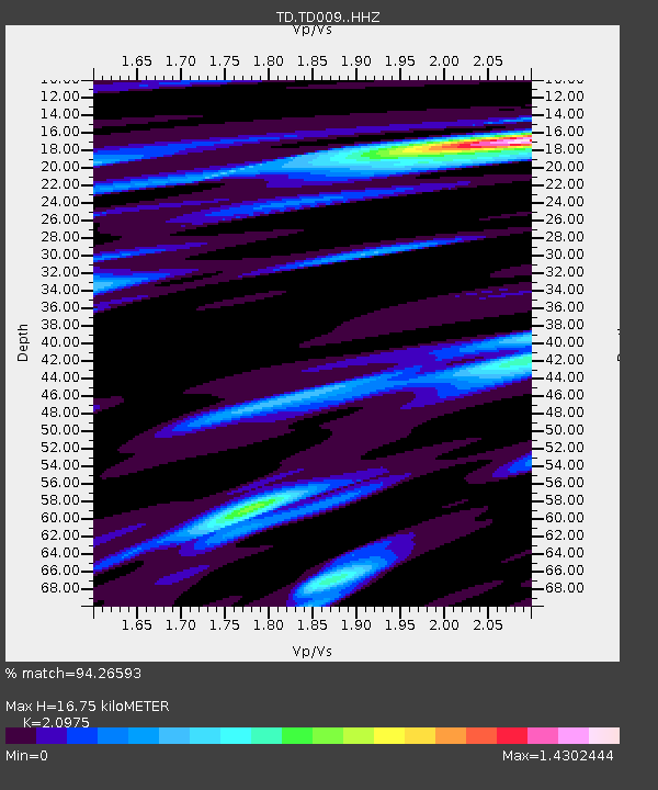
| Estimated Moho Depth: |
16.75 km |
| Estimated Crust Vp/Vs: |
2.10 |
| Assumed Crust Vp: |
6.142 km/s |
| Estimated Crust Vs: |
2.928 km/s |
| Estimated Crust Poisson's Ratio: |
0.35 |
|
| Radial Match: |
94.26593 % |
| Radial Bump: |
400 |
| Transverse Match: |
78.886955 % |
| Transverse Bump: |
400 |
| SOD ConfigId: |
21166931 |
| Insert Time: |
2020-04-30 08:24:33.293 +0000 |
| GWidth: |
2.5 |
| Max Bumps: |
400 |
| Tol: |
0.001 |
|

Signal To Noise
| Channel | StoN | STA | LTA |
| TD:TD009: :HHZ:20200416T08:12:04.210007Z | 7.1350665 | 1.1407068E-6 | 1.5987332E-7 |
| TD:TD009: :HH1:20200416T08:12:04.210007Z | 5.7176657 | 4.892019E-7 | 8.5559726E-8 |
| TD:TD009: :HH2:20200416T08:12:04.210007Z | 4.969052 | 5.454476E-7 | 1.09768955E-7 |
| Arrivals |
| Ps | 3.2 SECOND |
| PpPs | 8.0 SECOND |
| PsPs/PpSs | 11 SECOND |


