You are here: Home > Network List > WY - Yellowstone Wyoming Seismic Network Stations List
> Station YHH Holmes Hill, YNP, WY, USA > Earthquake Result Viewer
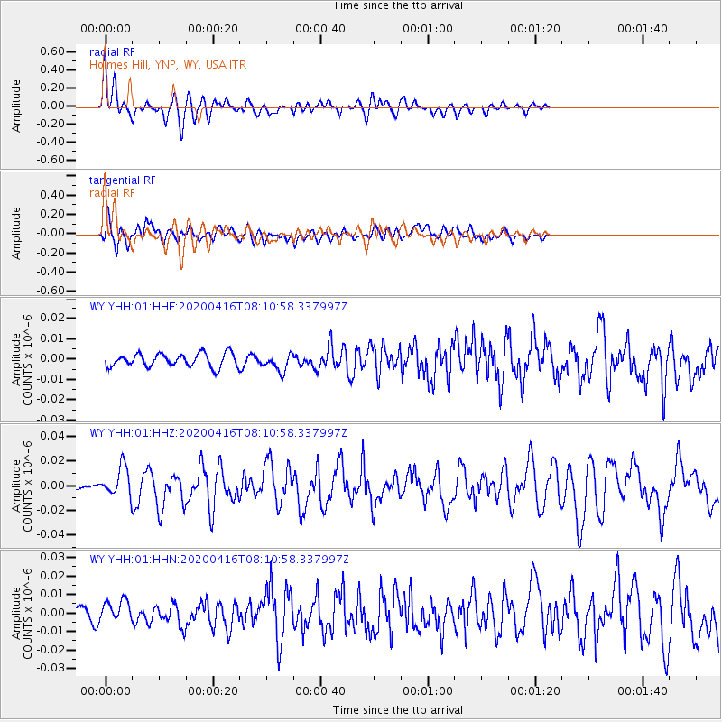
YHH Holmes Hill, YNP, WY, USA - Earthquake Result Viewer
*The percent match for this event was below the threshold and hence no stack was calculated.
| Earthquake location: |
North Of Honduras |
| Earthquake latitude/longitude: |
16.9/-85.7 |
| Earthquake time(UTC): |
2020/04/16 (107) 08:04:37 GMT |
| Earthquake Depth: |
10 km |
| Earthquake Magnitude: |
6.0 mww |
| Earthquake Catalog/Contributor: |
NEIC PDE/us |
|
| Network: |
WY Yellowstone Wyoming Seismic Network |
| Station: |
YHH Holmes Hill, YNP, WY, USA |
| Lat/Lon: |
44.79 N/110.85 W |
| Elevation: |
2717 m |
|
| Distance: |
34.9 deg |
| Az: |
328.07 deg |
| Baz: |
134.688 deg |
| Ray Param: |
$rayparam |
*The percent match for this event was below the threshold and hence was not used in the summary stack. |
|
| Radial Match: |
68.512924 % |
| Radial Bump: |
400 |
| Transverse Match: |
65.16231 % |
| Transverse Bump: |
400 |
| SOD ConfigId: |
21166931 |
| Insert Time: |
2020-04-30 08:26:52.115 +0000 |
| GWidth: |
2.5 |
| Max Bumps: |
400 |
| Tol: |
0.001 |
|
Signal To Noise
| Channel | StoN | STA | LTA |
| WY:YHH:01:HHZ:20200416T08:10:58.337997Z | 6.030759 | 1.2033005E-8 | 1.9952722E-9 |
| WY:YHH:01:HHN:20200416T08:10:58.337997Z | 2.722618 | 5.7688756E-9 | 2.1188706E-9 |
| WY:YHH:01:HHE:20200416T08:10:58.337997Z | 1.3249048 | 4.289795E-9 | 3.2378138E-9 |
| Arrivals |
| Ps | |
| PpPs | |
| PsPs/PpSs | |


