You are here: Home > Network List > CN - Canadian National Seismograph Network Stations List
> Station INK INUVIK, NT > Earthquake Result Viewer
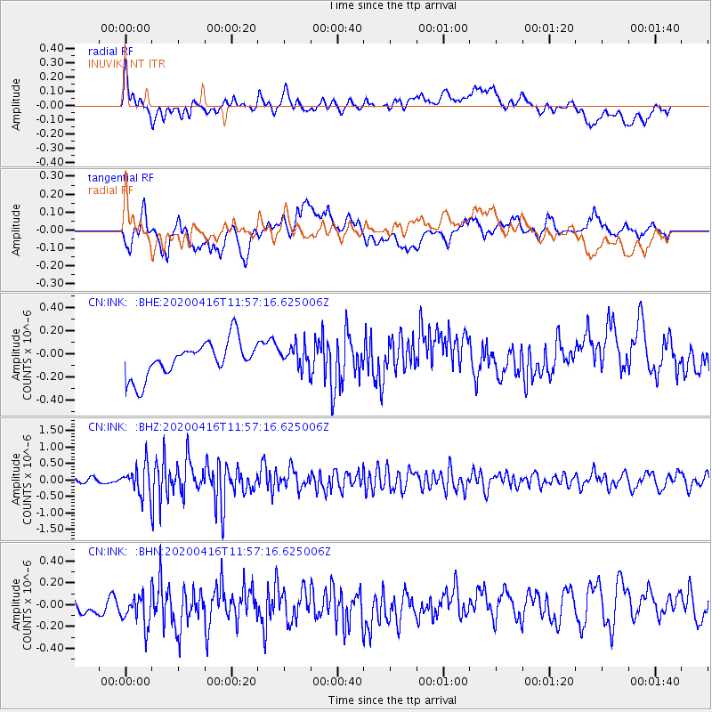
INK INUVIK, NT - Earthquake Result Viewer
*The percent match for this event was below the threshold and hence no stack was calculated.
| Earthquake location: |
Myanmar |
| Earthquake latitude/longitude: |
22.8/94.0 |
| Earthquake time(UTC): |
2020/04/16 (107) 11:45:23 GMT |
| Earthquake Depth: |
10 km |
| Earthquake Magnitude: |
5.9 mww |
| Earthquake Catalog/Contributor: |
NEIC PDE/us |
|
| Network: |
CN Canadian National Seismograph Network |
| Station: |
INK INUVIK, NT |
| Lat/Lon: |
68.31 N/133.53 W |
| Elevation: |
44 m |
|
| Distance: |
82.8 deg |
| Az: |
16.053 deg |
| Baz: |
316.651 deg |
| Ray Param: |
$rayparam |
*The percent match for this event was below the threshold and hence was not used in the summary stack. |
|
| Radial Match: |
49.696037 % |
| Radial Bump: |
400 |
| Transverse Match: |
60.445885 % |
| Transverse Bump: |
400 |
| SOD ConfigId: |
21166931 |
| Insert Time: |
2020-04-30 11:50:56.652 +0000 |
| GWidth: |
2.5 |
| Max Bumps: |
400 |
| Tol: |
0.001 |
|
Signal To Noise
| Channel | StoN | STA | LTA |
| CN:INK: :BHZ:20200416T11:57:16.625006Z | 5.449622 | 4.6420178E-7 | 8.518054E-8 |
| CN:INK: :BHN:20200416T11:57:16.625006Z | 1.6464617 | 1.7213245E-7 | 1.04546885E-7 |
| CN:INK: :BHE:20200416T11:57:16.625006Z | 0.6486444 | 9.742193E-8 | 1.5019313E-7 |
| Arrivals |
| Ps | |
| PpPs | |
| PsPs/PpSs | |


