You are here: Home > Network List > TA - USArray Transportable Network (new EarthScope stations) Stations List
> Station C19K Lookout Ridge, AK, USA > Earthquake Result Viewer
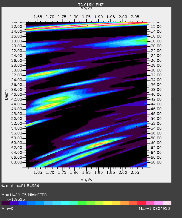
C19K Lookout Ridge, AK, USA - Earthquake Result Viewer
| Earthquake location: |
Myanmar |
| Earthquake latitude/longitude: |
22.8/94.0 |
| Earthquake time(UTC): |
2020/04/16 (107) 11:45:23 GMT |
| Earthquake Depth: |
10 km |
| Earthquake Magnitude: |
5.9 mww |
| Earthquake Catalog/Contributor: |
NEIC PDE/us |
|
| Network: |
TA USArray Transportable Network (new EarthScope stations) |
| Station: |
C19K Lookout Ridge, AK, USA |
| Lat/Lon: |
69.10 N/159.59 W |
| Elevation: |
745 m |
|
| Distance: |
74.6 deg |
| Az: |
20.918 deg |
| Baz: |
293.292 deg |
| Ray Param: |
0.052250803 |
| Estimated Moho Depth: |
11.25 km |
| Estimated Crust Vp/Vs: |
1.85 |
| Assumed Crust Vp: |
6.221 km/s |
| Estimated Crust Vs: |
3.358 km/s |
| Estimated Crust Poisson's Ratio: |
0.29 |
|
| Radial Match: |
81.54984 % |
| Radial Bump: |
400 |
| Transverse Match: |
81.938446 % |
| Transverse Bump: |
400 |
| SOD ConfigId: |
21166931 |
| Insert Time: |
2020-04-30 11:55:25.582 +0000 |
| GWidth: |
2.5 |
| Max Bumps: |
400 |
| Tol: |
0.001 |
|

Signal To Noise
| Channel | StoN | STA | LTA |
| TA:C19K: :BHZ:20200416T11:56:31.64997Z | 5.9281454 | 4.1186348E-7 | 6.947594E-8 |
| TA:C19K: :BHN:20200416T11:56:31.64997Z | 1.5884229 | 7.056697E-8 | 4.4425807E-8 |
| TA:C19K: :BHE:20200416T11:56:31.64997Z | 1.1756234 | 9.6831556E-8 | 8.2366135E-8 |
| Arrivals |
| Ps | 1.6 SECOND |
| PpPs | 5.0 SECOND |
| PsPs/PpSs | 6.6 SECOND |


