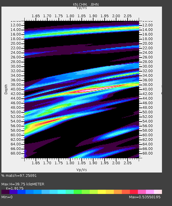
CHM KN.CHM - Earthquake Result Viewer
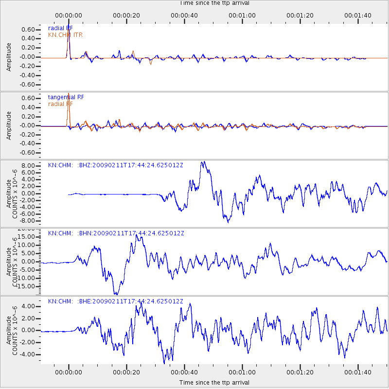
Earthquake location: Talaud Islands, Indonesia
Earthquake latitude/longitude: 3.9/126.4
Earthquake time(UTC): 2009/02/11 (042) 17:34:50 GMT
Earthquake Depth: 22 km
Earthquake Magnitude: 6.6 MB, 7.2 MS, 7.2 MW, 7.1 MW
Earthquake Catalog/Contributor: WHDF/NEIC
Network: KN Kyrgyz Seismic Telemetry Network
Station: CHM KN.CHM
Lat/Lon: 43.00 N/74.75 E
Elevation: 655 m
Distance: 60.0 deg
Az: 318.372 deg
Baz: 115.39 deg
Ray Param: 0.061789636
Estimated Moho Depth: 39.75 km
Estimated Crust Vp/Vs: 1.92
Assumed Crust Vp: 6.306 km/s
Estimated Crust Vs: 3.289 km/s
Estimated Crust Poisson's Ratio: 0.31
Radial Match: 97.25891 %
Radial Bump: 333
Transverse Match: 87.352196 %
Transverse Bump: 400
SOD ConfigId: 2658
Insert Time: 2010-03-08 19:20:59.928 +0000
GWidth: 2.5
Max Bumps: 400
Tol: 0.001

Signal To Noise

ChannelStoNSTALTA
KN:CHM: :BHN:20090211T17:44:24.625012Z15.4032481.6958189E-61.10094895E-7
KN:CHM: :BHE:20090211T17:44:24.625012Z3.71451233.7184387E-71.00105694E-7
KN:CHM: :BHZ:20090211T17:44:24.625012Z12.2887298.517861E-76.931442E-8
Arrivals
Ps6.0 SECOND
PpPs18 SECOND
PsPs/PpSs24 SECOND