You are here: Home > Network List > TA - USArray Transportable Network (new EarthScope stations) Stations List
> Station E17K Hotham Inlet, AK, USA > Earthquake Result Viewer
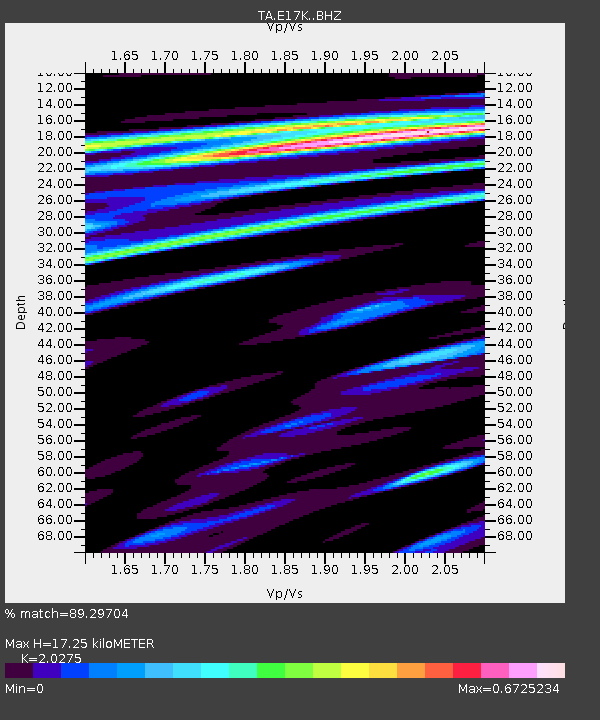
E17K Hotham Inlet, AK, USA - Earthquake Result Viewer
| Earthquake location: |
Myanmar |
| Earthquake latitude/longitude: |
22.8/94.0 |
| Earthquake time(UTC): |
2020/04/16 (107) 11:45:23 GMT |
| Earthquake Depth: |
10 km |
| Earthquake Magnitude: |
5.9 mww |
| Earthquake Catalog/Contributor: |
NEIC PDE/us |
|
| Network: |
TA USArray Transportable Network (new EarthScope stations) |
| Station: |
E17K Hotham Inlet, AK, USA |
| Lat/Lon: |
67.08 N/161.83 W |
| Elevation: |
233 m |
|
| Distance: |
74.6 deg |
| Az: |
23.2 deg |
| Baz: |
291.824 deg |
| Ray Param: |
0.052248176 |
| Estimated Moho Depth: |
17.25 km |
| Estimated Crust Vp/Vs: |
2.03 |
| Assumed Crust Vp: |
6.276 km/s |
| Estimated Crust Vs: |
3.095 km/s |
| Estimated Crust Poisson's Ratio: |
0.34 |
|
| Radial Match: |
89.29704 % |
| Radial Bump: |
355 |
| Transverse Match: |
78.39701 % |
| Transverse Bump: |
400 |
| SOD ConfigId: |
21166931 |
| Insert Time: |
2020-04-30 11:55:46.963 +0000 |
| GWidth: |
2.5 |
| Max Bumps: |
400 |
| Tol: |
0.001 |
|

Signal To Noise
| Channel | StoN | STA | LTA |
| TA:E17K: :BHZ:20200416T11:56:31.674994Z | 5.6076407 | 3.8405503E-7 | 6.848781E-8 |
| TA:E17K: :BHN:20200416T11:56:31.674994Z | 1.7556624 | 9.952345E-8 | 5.6687117E-8 |
| TA:E17K: :BHE:20200416T11:56:31.674994Z | 4.3765464 | 1.5732856E-7 | 3.594811E-8 |
| Arrivals |
| Ps | 2.9 SECOND |
| PpPs | 8.1 SECOND |
| PsPs/PpSs | 11 SECOND |


