You are here: Home > Network List > TA - USArray Transportable Network (new EarthScope stations) Stations List
> Station E25K Arctic Village, AK, USA > Earthquake Result Viewer
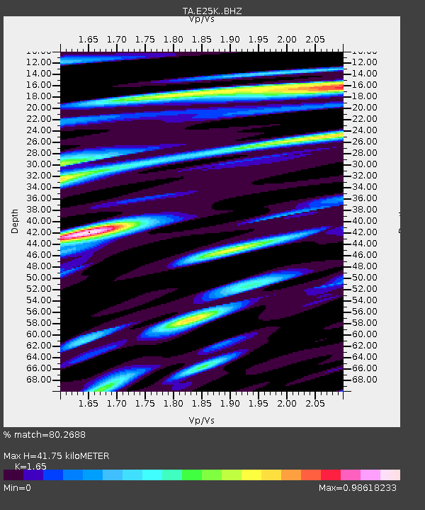
E25K Arctic Village, AK, USA - Earthquake Result Viewer
| Earthquake location: |
Myanmar |
| Earthquake latitude/longitude: |
22.8/94.0 |
| Earthquake time(UTC): |
2020/04/16 (107) 11:45:23 GMT |
| Earthquake Depth: |
10 km |
| Earthquake Magnitude: |
5.9 mww |
| Earthquake Catalog/Contributor: |
NEIC PDE/us |
|
| Network: |
TA USArray Transportable Network (new EarthScope stations) |
| Station: |
E25K Arctic Village, AK, USA |
| Lat/Lon: |
68.12 N/145.57 W |
| Elevation: |
652 m |
|
| Distance: |
79.5 deg |
| Az: |
19.192 deg |
| Baz: |
305.957 deg |
| Ray Param: |
0.048908297 |
| Estimated Moho Depth: |
41.75 km |
| Estimated Crust Vp/Vs: |
1.65 |
| Assumed Crust Vp: |
6.455 km/s |
| Estimated Crust Vs: |
3.912 km/s |
| Estimated Crust Poisson's Ratio: |
0.21 |
|
| Radial Match: |
80.2688 % |
| Radial Bump: |
400 |
| Transverse Match: |
68.17383 % |
| Transverse Bump: |
400 |
| SOD ConfigId: |
21166931 |
| Insert Time: |
2020-04-30 11:55:57.866 +0000 |
| GWidth: |
2.5 |
| Max Bumps: |
400 |
| Tol: |
0.001 |
|

Signal To Noise
| Channel | StoN | STA | LTA |
| TA:E25K: :BHZ:20200416T11:56:59.39997Z | 6.3445673 | 3.685424E-7 | 5.8087867E-8 |
| TA:E25K: :BHN:20200416T11:56:59.39997Z | 1.5942314 | 9.287083E-8 | 5.8254294E-8 |
| TA:E25K: :BHE:20200416T11:56:59.39997Z | 2.3028784 | 1.3846949E-7 | 6.0128876E-8 |
| Arrivals |
| Ps | 4.3 SECOND |
| PpPs | 17 SECOND |
| PsPs/PpSs | 21 SECOND |


