You are here: Home > Network List > TA - USArray Transportable Network (new EarthScope stations) Stations List
> Station E28M Babbage River, YT, CAN > Earthquake Result Viewer
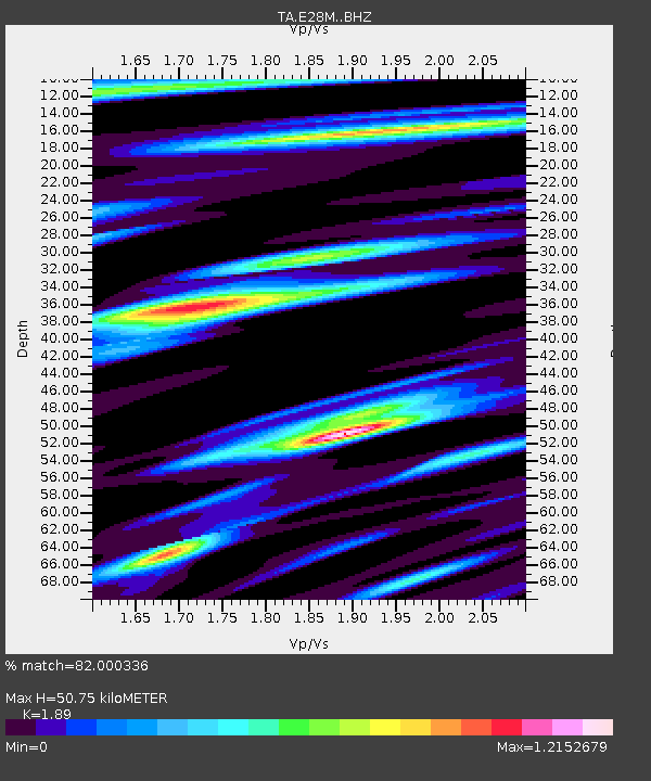
E28M Babbage River, YT, CAN - Earthquake Result Viewer
| Earthquake location: |
Myanmar |
| Earthquake latitude/longitude: |
22.8/94.0 |
| Earthquake time(UTC): |
2020/04/16 (107) 11:45:23 GMT |
| Earthquake Depth: |
10 km |
| Earthquake Magnitude: |
5.9 mww |
| Earthquake Catalog/Contributor: |
NEIC PDE/us |
|
| Network: |
TA USArray Transportable Network (new EarthScope stations) |
| Station: |
E28M Babbage River, YT, CAN |
| Lat/Lon: |
68.60 N/139.53 W |
| Elevation: |
474 m |
|
| Distance: |
81.0 deg |
| Az: |
17.391 deg |
| Baz: |
311.255 deg |
| Ray Param: |
0.047918998 |
| Estimated Moho Depth: |
50.75 km |
| Estimated Crust Vp/Vs: |
1.89 |
| Assumed Crust Vp: |
6.316 km/s |
| Estimated Crust Vs: |
3.342 km/s |
| Estimated Crust Poisson's Ratio: |
0.31 |
|
| Radial Match: |
82.000336 % |
| Radial Bump: |
400 |
| Transverse Match: |
79.79523 % |
| Transverse Bump: |
400 |
| SOD ConfigId: |
21166931 |
| Insert Time: |
2020-04-30 11:56:00.757 +0000 |
| GWidth: |
2.5 |
| Max Bumps: |
400 |
| Tol: |
0.001 |
|

Signal To Noise
| Channel | StoN | STA | LTA |
| TA:E28M: :BHZ:20200416T11:57:07.14997Z | 6.488942 | 3.664169E-7 | 5.6467897E-8 |
| TA:E28M: :BHN:20200416T11:57:07.14997Z | 1.4204954 | 7.1884486E-8 | 5.060522E-8 |
| TA:E28M: :BHE:20200416T11:57:07.14997Z | 2.0718865 | 1.3212096E-7 | 6.3768425E-8 |
| Arrivals |
| Ps | 7.3 SECOND |
| PpPs | 23 SECOND |
| PsPs/PpSs | 30 SECOND |


