You are here: Home > Network List > TA - USArray Transportable Network (new EarthScope stations) Stations List
> Station F21K Alatna River, AK, USA > Earthquake Result Viewer
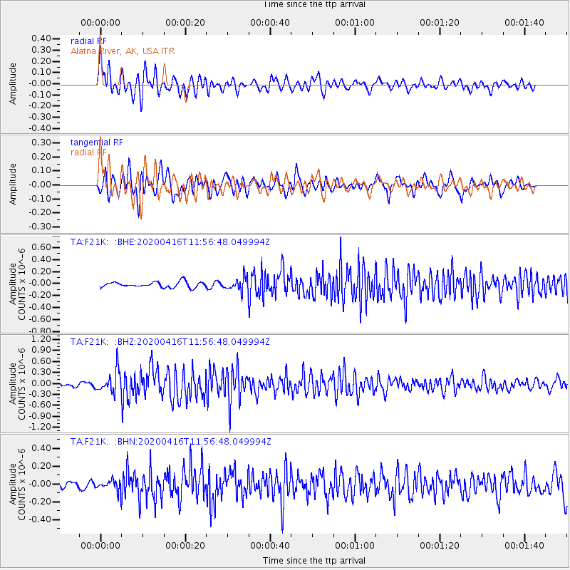
F21K Alatna River, AK, USA - Earthquake Result Viewer
*The percent match for this event was below the threshold and hence no stack was calculated.
| Earthquake location: |
Myanmar |
| Earthquake latitude/longitude: |
22.8/94.0 |
| Earthquake time(UTC): |
2020/04/16 (107) 11:45:23 GMT |
| Earthquake Depth: |
10 km |
| Earthquake Magnitude: |
5.9 mww |
| Earthquake Catalog/Contributor: |
NEIC PDE/us |
|
| Network: |
TA USArray Transportable Network (new EarthScope stations) |
| Station: |
F21K Alatna River, AK, USA |
| Lat/Lon: |
67.22 N/153.48 W |
| Elevation: |
597 m |
|
| Distance: |
77.5 deg |
| Az: |
21.626 deg |
| Baz: |
299.126 deg |
| Ray Param: |
$rayparam |
*The percent match for this event was below the threshold and hence was not used in the summary stack. |
|
| Radial Match: |
74.224106 % |
| Radial Bump: |
400 |
| Transverse Match: |
72.57684 % |
| Transverse Bump: |
400 |
| SOD ConfigId: |
21166931 |
| Insert Time: |
2020-04-30 11:56:12.522 +0000 |
| GWidth: |
2.5 |
| Max Bumps: |
400 |
| Tol: |
0.001 |
|
Signal To Noise
| Channel | StoN | STA | LTA |
| TA:F21K: :BHZ:20200416T11:56:48.049994Z | 5.2392993 | 3.0528676E-7 | 5.8268622E-8 |
| TA:F21K: :BHN:20200416T11:56:48.049994Z | 1.1520056 | 6.2066455E-8 | 5.387687E-8 |
| TA:F21K: :BHE:20200416T11:56:48.049994Z | 2.3992167 | 1.0990262E-7 | 4.5807706E-8 |
| Arrivals |
| Ps | |
| PpPs | |
| PsPs/PpSs | |


